Laugar geodata
Laugar (Northeast) is a populated place; located in Iceland in Atlantic/Reykjavik (GMT+0) time zone. With population of 1,001 people, there are 31 cities with bigger population in this country. Compared to other cities in Iceland, 80.4% of cities are located further ↓South; 80.4% of cities are located further ←West and 87% of cities have lower elevation than Laugar. Note1


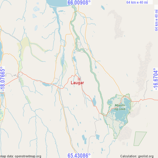
Laugar GPS coordinates[2]
65° 43' 17.724" North, 17° 22' 24.672" West
| Map corner | latitude | longitude |
|---|---|---|
| Upper-left | 66.00908°, | -18.07665° |
| Center: | 65.72159°, | -17.37352° |
| Lower-right: | 65.43086°, | -16.6704° |
| Map W x H: | 64.3×64.3 km | = 40×40mi |
| max Lat: | 66.15917° ⇑19.6% North |
| Laugar: | 65.72159° |
| min Lat: | ⇓80.4% South 63.44273° |
| min Long | Laugar | max Long |
| -23.99596° | -17.37352° | -13.68368° |
| W 80.4%⇐ | ⇒19.6% E |
Elevation
Elevation of Laugar is 40 m = 131 ft, and this is 18.7 m = 61 ft above average elevation for this country.
| Max E: |
105 m = 344 ft | 13% |
| Laugar | 40 m 131 ft | |
| Avg. | 21.3 m = 70 ft | |
Min E: |
1 m = 3 ft | 87% |
See also: Iceland elevation on elevation.city.
Geographical zone
Laugar is located in North temperate zone (between Tropic of Cancer and the Arctic Circle). Distance of this North polar circle is 93.6 km =58.2 mi to North.| Distance of | km | miles | from Laugar |
|---|---|---|---|
| North Pole | 2699.5 | 1677.4 | to North |
| Arctic Circle | 93.6 | 58.2 | to North |
| Tropic Cancer | 4701.6 | 2921.4 | to South |
| Equator | 7307.6 | 4540.7 | to South |


Nearby cities:
15 places around Laugar: (largest is in red/bold)
• Akureyri
33 km =20.5 mi,  262°
262°
• Blönduós
133.2 km =82.8 mi,  267°
267°
• Dalvík
59.4 km =36.9 mi,  297°
297°
• Egilsstaðir
146.4 km =91 mi,  110°
110°
• Eskifjörður
171.3 km =106.4 mi, 114°
• Fáskrúðsfjörður
178.8 km =111.1 mi,  119°
119°
• Hvammstangi
168.1 km =104.5 mi, 257°
• Húsavík
35.6 km =22.1 mi,  2°
2°
• Reyðarfjörður
165.1 km =102.6 mi, 117°
• Sauðárkrókur
103.6 km =64.4 mi, 271°
• Seyðisfjörður
163.6 km =101.7 mi, 108°
• Siglufjörður
84.4 km =52.4 mi, 304°
• Skagaströnd
134.1 km =83.3 mi, 274°
• Vopnafjörður
116.4 km =72.3 mi,  88°
88°
• Ólafsfjörður
69.3 km =43.1 mi, 303°
Sources, notices
• [Note1] Compared only with cities in Iceland existing in our database
• [Src1] Map data: © OpenStreetMap contributors (CC-BY-SA)
• [Src2] Other city data from geonames.org with taken over terms of usage.
• [Src3] Geographical zone / Annual Mean Temperature by Robert A. Rohde @ Wikipedia
