Egilsstaðir geodata
Egilsstaðir (East) is a seat of a first-order administrative division; located in Iceland in Atlantic/Reykjavik (GMT+0) time zone. With population of 2,303 people, there are 14 cities with bigger population in this country. Compared to other cities in Iceland, 69.6% of cities are located further ↓South; 89.1% of cities are located further ←West and 71.7% of cities have lower elevation than Egilsstaðir. Note1


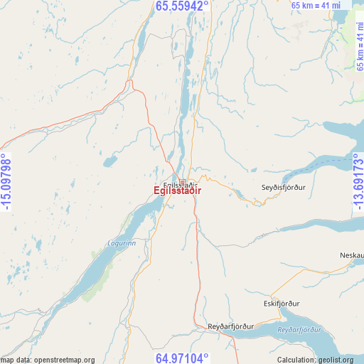
Egilsstaðir GPS coordinates[2]
65° 16' 0.732" North, 14° 23' 41.46" West
| Map corner | latitude | longitude |
|---|---|---|
| Upper-left | 65.55942°, | -15.09798° |
| Center: | 65.26687°, | -14.39485° |
| Lower-right: | 64.97104°, | -13.69173° |
| Map W x H: | 65.4×65.4 km | = 40.6×40.6mi |
| max Lat: | 66.15917° ⇑30.4% North |
| Egilsstaðir: | 65.26687° |
| min Lat: | ⇓69.6% South 63.44273° |
| min Long | Egilsstaðir | max Long |
| -23.99596° | -14.39485° | -13.68368° |
| W 89.1%⇐ | ⇒10.9% E |
Elevation
Elevation of Egilsstaðir is 33 m = 108 ft, and this is 11.7 m = 38 ft above average elevation for this country.
| Max E: |
105 m = 344 ft | 28.3% |
| Egilsstaðir | 33 m 108 ft | |
| Avg. | 21.3 m = 70 ft | |
Min E: |
1 m = 3 ft | 71.7% |
See also: Iceland elevation on elevation.city.
Geographical zone
Egilsstaðir is located in North temperate zone (between Tropic of Cancer and the Arctic Circle). Distance of this North polar circle is 144.2 km =89.6 mi to North.| Distance of | km | miles | from Egilsstaðir |
|---|---|---|---|
| North Pole | 2750.1 | 1708.8 | to North |
| Arctic Circle | 144.2 | 89.6 | to North |
| Tropic Cancer | 4651.1 | 2890.1 | to South |
| Equator | 7257 | 4509.3 | to South |


Nearby cities:
10 places around Egilsstaðir: (largest is in red/bold)
• Akureyri
176.6 km =109.7 mi,  285°
285°
• Eskifjörður
27.9 km =17.3 mi,  140°
140°
• Fáskrúðsfjörður
41.3 km =25.7 mi,  154°
154°
• Höfn
119.1 km =74 mi,  198°
198°
• Húsavík
160 km =99.4 mi,  302°
302°
• Laugar
146.4 km =91 mi, 290°
• Neskaupstaður
35.7 km =22.2 mi,  111°
111°
• Reyðarfjörður
27.4 km =17 mi,  162°
162°
• Seyðisfjörður
18.1 km =11.2 mi,  92°
92°
• Vopnafjörður
58 km =36 mi,  339°
339°
Sources, notices
• [Note1] Compared only with cities in Iceland existing in our database
• [Src1] Map data: © OpenStreetMap contributors (CC-BY-SA)
• [Src2] Other city data from geonames.org with taken over terms of usage.
• [Src3] Geographical zone / Annual Mean Temperature by Robert A. Rohde @ Wikipedia
