Húsavík geodata
Húsavík (Northeast) is a populated place; located in Iceland in Atlantic/Reykjavik (GMT+0) time zone. With population of 2,228 people, there are 16 cities with bigger population in this country. Compared to other cities in Iceland, 91.3% of cities are located further ↓South; 82.6% of cities are located further ←West and 97.8% of cities have lower elevation than Húsavík. Note1


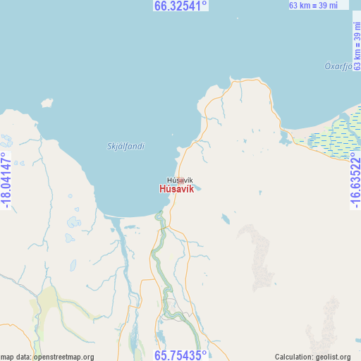
Húsavík GPS coordinates[2]
66° 2' 29.328" North, 17° 20' 18.024" West
| Map corner | latitude | longitude |
|---|---|---|
| Upper-left | 66.32541°, | -18.04147° |
| Center: | 66.04148°, | -17.33834° |
| Lower-right: | 65.75435°, | -16.63522° |
| Map W x H: | 63.5×63.5 km | = 39.5×39.5mi |
| max Lat: | 66.15917° ⇑8.7% North |
| Húsavík: | 66.04148° |
| min Lat: | ⇓91.3% South 63.44273° |
| min Long | Húsavík | max Long |
| -23.99596° | -17.33834° | -13.68368° |
| W 82.6%⇐ | ⇒17.4% E |
Elevation
Elevation of Húsavík is 58 m = 190 ft, and this is 36.7 m = 120 ft above average elevation for this country.
| Max E: |
105 m = 344 ft | 2.2% |
| Húsavík | 58 m 190 ft | |
| Avg. | 21.3 m = 70 ft | |
Min E: |
1 m = 3 ft | 97.8% |
See also: Iceland elevation on elevation.city.
Geographical zone
Húsavík is located in North temperate zone (between Tropic of Cancer and the Arctic Circle). Distance of this North polar circle is 58 km =36 mi to North.| Distance of | km | miles | from Húsavík |
|---|---|---|---|
| North Pole | 2663.9 | 1655.3 | to North |
| Arctic Circle | 58 | 36 | to North |
| Tropic Cancer | 4737.2 | 2943.6 | to South |
| Equator | 7343.1 | 4562.8 | to South |


Nearby cities:
15 places around Húsavík: (largest is in red/bold)
• Akureyri
52.4 km =32.6 mi,  220°
220°
• Blönduós
140.4 km =87.2 mi,  252°
252°
• Dalvík
54.4 km =33.8 mi,  261°
261°
• Egilsstaðir
160 km =99.4 mi,  122°
122°
• Eskifjörður
187 km =116.2 mi,  125°
125°
• Hvammstangi
179.7 km =111.7 mi, 246°
• Laugar
35.6 km =22.1 mi,  182°
182°
• Neskaupstaður
195 km =121.2 mi, 120°
• Reyðarfjörður
182.3 km =113.3 mi, 128°
• Sauðárkrókur
109.5 km =68 mi, 252°
• Seyðisfjörður
175.7 km =109.2 mi, 119°
• Siglufjörður
71.8 km =44.6 mi,  279°
279°
• Skagaströnd
136.6 km =84.9 mi, 259°
• Vopnafjörður
118.3 km =73.5 mi,  105°
105°
• Ólafsfjörður
59 km =36.7 mi,  272°
272°
Sources, notices
• [Note1] Compared only with cities in Iceland existing in our database
• [Src1] Map data: © OpenStreetMap contributors (CC-BY-SA)
• [Src2] Other city data from geonames.org with taken over terms of usage.
• [Src3] Geographical zone / Annual Mean Temperature by Robert A. Rohde @ Wikipedia
