Lavinaio-Monterosso geodata
Lavinaio-Monterosso (Sicily) is a populated place; located in Italy in Europe/Rome (GMT+2) time zone. With population of 1,398 people, there are 5366 cities with bigger population in this country. Compared to other cities in Italy, 98.3% of cities are located further ↑North; 88% of cities are located further ←West and 74.6% of cities have lower elevation than Lavinaio-Monterosso. Note1


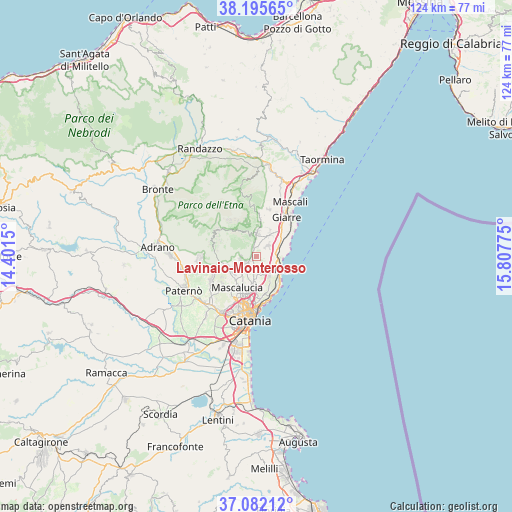
Lavinaio-Monterosso GPS coordinates[2]
37° 38' 27.492" North, 15° 6' 16.632" East
| Map corner | latitude | longitude |
|---|---|---|
| Upper-left | 38.19565°, | 14.4015° |
| Center: | 37.64097°, | 15.10462° |
| Lower-right: | 37.08212°, | 15.80775° |
| Map W x H: | 123.8×123.8 km | = 76.9×76.9mi |
| max Lat: | 47.04031° ⇑98.3% North |
| Lavinaio-Monterosso: | 37.64097° |
| min Lat: | ⇓1.7% South 35.50142° |
| min Long | Lavinaio-Monter | max Long |
| 6.69888° | 15.10462° | 18.48682° |
| W 88%⇐ | ⇒12% E |
Elevation
Elevation of Lavinaio-Monterosso is 447 m = 1467 ft, and this is 140.3 m = 460 ft above average elevation for this country.
| Max E: |
2085 m = 6841 ft | 25.4% |
| Lavinaio-Monterosso | 447 m 1467 ft | |
| Avg. | 306.7 m = 1006 ft | |
Min E: |
-4 m = -13 ft | 74.6% |
See also: Italy elevation on elevation.city.
Geographical zone
Lavinaio-Monterosso is located in North temperate zone (between Tropic of Cancer and the Arctic Circle). Distance of this Northern Tropic circle is 1579.4 km =981.4 mi to South.| Distance of | km | miles | from Lavinaio-Monterosso |
|---|---|---|---|
| North Pole | 5821.8 | 3617.5 | to North |
| Arctic Circle | 3215.9 | 1998.3 | to North |
| Tropic Cancer | 1579.4 | 981.4 | to South |
| Equator | 4185.3 | 2600.6 | to South |


Nearby cities:
15 places around Lavinaio-Monterosso: (largest is in red/bold)
• Aci Bonaccorsi
5 km =3.1 mi,  177°
177°
• Aci Catena
5.1 km =3.2 mi,  139°
139°
• Aci Sant'Antonio
4.3 km =2.7 mi,  158°
158°
• Acireale
6.5 km =4 mi,  123°
123°
• Linera
3.8 km =2.4 mi,  47°
47°
• Maugeri
6.2 km =3.9 mi,  169°
169°
• Monterosso
1.2 km =0.7 mi,  279°
279°
• Nicolosi
7.1 km =4.4 mi,  252°
252°
• Pedara
4.6 km =2.9 mi, 245°
• Pennisi
1.9 km =1.2 mi,  60°
60°
• Santa Maria la Stella
2.4 km =1.5 mi, 143°
• Santa Venerina
6.3 km =3.9 mi,  28°
28°
• Trecastagni
3.7 km =2.3 mi,  219°
219°
• Viagrande
3.5 km =2.2 mi,  189°
189°
• Zafferana Etnea
4.2 km =2.6 mi,  359°
359°
Sources, notices
• [Note1] Compared only with cities in Italy existing in our database
• [Src1] Map data: © OpenStreetMap contributors (CC-BY-SA)
• [Src2] Other city data from geonames.org with taken over terms of usage.
• [Src3] Geographical zone / Annual Mean Temperature by Robert A. Rohde @ Wikipedia
