San Giovanni in Fiore geodata
San Giovanni in Fiore (Calabria) is a seat of a third-order administrative division; located in Italy in Europe/Rome (GMT+2) time zone. With population of 17,358 people, there are 509 cities with bigger population in this country. Compared to other cities in Italy, 91.6% of cities are located further ↑North; 97.2% of cities are located further ←West and 97.2% of cities have lower elevation than San Giovanni in Fiore. Note1
Administrative division(s):
- Level 1: Calabria
- Level 2: Provincia di Cosenza
- Level 3: San Giovanni in Fiore
Current local time in San Giovanni in Fiore:
07:56 PM, WednesdayDifference from your time zone: hours


San Giovanni in Fiore GPS coordinates[2]
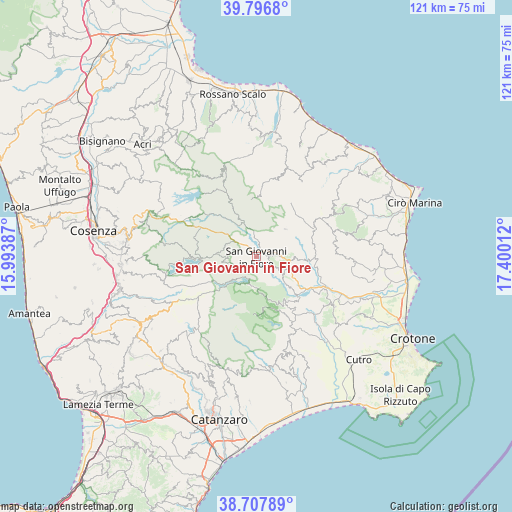
39° 15' 16.056" North, 16° 41' 49.164" East
| Map corner | latitude | longitude |
|---|---|---|
| Upper-left | 39.7968°, | 15.99387° |
| Center: | 39.25446°, | 16.69699° |
| Lower-right: | 38.70789°, | 17.40012° |
| Map W x H: | 121.1×121.1 km | = 75.2×75.2mi |
| max Lat: | 47.04031° ⇑91.6% North |
| San Giovanni in Fiore: | 39.25446° |
| min Lat: | ⇓8.4% South 35.50142° |
| min Long | San Giovanni in | max Long |
| 6.69888° | 16.69699° | 18.48682° |
| W 97.2%⇐ | ⇒2.8% E |
Elevation
Elevation of San Giovanni in Fiore is 1017 m = 3337 ft, and this is 710.3 m = 2330 ft above average elevation for this country.
| Max E: |
2085 m = 6841 ft | 2.8% |
| San Giovanni in Fiore | 1017 m 3337 ft | |
| Avg. | 306.7 m = 1006 ft | |
Min E: |
-4 m = -13 ft | 97.2% |
See also: Italy elevation on elevation.city.
Geographical zone
San Giovanni in Fiore is located in North temperate zone (between Tropic of Cancer and the Arctic Circle). Distance of this Northern Tropic circle is 1758.8 km =1092.9 mi to South.| Distance of | km | miles | from San Giovanni in Fiore |
|---|---|---|---|
| North Pole | 5642.4 | 3506 | to North |
| Arctic Circle | 3036.5 | 1886.8 | to North |
| Tropic Cancer | 1758.8 | 1092.9 | to South |
| Equator | 4364.7 | 2712.1 | to South |


Nearby cities:
15 places around San Giovanni in Fiore: (largest is in red/bold)
• Belvedere Spinello
17.6 km =10.9 mi,  107°
107°
• Bocchigliero
18.9 km =11.7 mi,  14°
14°
• Caccuri
7.7 km =4.8 mi, 114°
• Campana
20.7 km =12.9 mi,  31°
31°
• Castelsilano
6.3 km =3.9 mi,  74°
74°
• Cerenzia
7.9 km =4.9 mi,  97°
97°
• Cotronei
12.6 km =7.8 mi,  146°
146°
• Foresta
19.9 km =12.4 mi, 149°
• Mesoraca
21 km =13 mi,  158°
158°
• Pagliarelle
13.5 km =8.4 mi, 159°
• Pallagorio
19.1 km =11.9 mi, 71°
• Petilia Policastro
17.3 km =10.7 mi, 155°
• Roccabernarda
19.6 km =12.2 mi,  133°
133°
• Savelli
9.4 km =5.8 mi,  46°
46°
• Verzino
15.2 km =9.4 mi,  64°
64°
Sources, notices
• [Note1] Compared only with cities in Italy existing in our database
• [Src1] Map data: © OpenStreetMap contributors (CC-BY-SA)
• [Src2] Other city data from geonames.org with taken over terms of usage.
• [Src3] Geographical zone / Annual Mean Temperature by Robert A. Rohde @ Wikipedia
