Castelsilano geodata
Castelsilano (Calabria) is a seat of a third-order administrative division; located in Italy in Europe/Rome (GMT+2) time zone. With population of 991 people, there are 6708 cities with bigger population in this country. Compared to other cities in Italy, 91.5% of cities are located further ↑North; 97.4% of cities are located further ←West and 95.7% of cities have lower elevation than Castelsilano. Note1


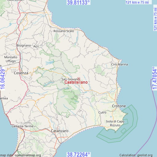
Castelsilano GPS coordinates[2]
39° 16' 8.76" North, 16° 46' 2.676" East
| Map corner | latitude | longitude |
|---|---|---|
| Upper-left | 39.81133°, | 16.06429° |
| Center: | 39.2691°, | 16.76741° |
| Lower-right: | 38.72264°, | 17.47054° |
| Map W x H: | 121.1×121.1 km | = 75.2×75.2mi |
| max Lat: | 47.04031° ⇑91.5% North |
| Castelsilano: | 39.2691° |
| min Lat: | ⇓8.5% South 35.50142° |
| min Long | Castelsilano | max Long |
| 6.69888° | 16.76741° | 18.48682° |
| W 97.4%⇐ | ⇒2.6% E |
Elevation
Elevation of Castelsilano is 911 m = 2989 ft, and this is 604.3 m = 1983 ft above average elevation for this country.
| Max E: |
2085 m = 6841 ft | 4.3% |
| Castelsilano | 911 m 2989 ft | |
| Avg. | 306.7 m = 1006 ft | |
Min E: |
-4 m = -13 ft | 95.7% |
See also: Italy elevation on elevation.city.
Geographical zone
Castelsilano is located in North temperate zone (between Tropic of Cancer and the Arctic Circle). Distance of this Northern Tropic circle is 1760.4 km =1093.9 mi to South.| Distance of | km | miles | from Castelsilano |
|---|---|---|---|
| North Pole | 5640.7 | 3505 | to North |
| Arctic Circle | 3034.9 | 1885.8 | to North |
| Tropic Cancer | 1760.4 | 1093.9 | to South |
| Equator | 4366.3 | 2713.1 | to South |


Nearby cities:
15 places around Castelsilano: (largest is in red/bold)
• Belvedere Spinello
12.8 km =8 mi,  122°
122°
• Bocchigliero
16.8 km =10.4 mi,  355°
355°
• Caccuri
4.9 km =3 mi,  169°
169°
• Campana
16.7 km =10.4 mi,  16°
16°
• Casabona
16.3 km =10.1 mi,  97°
97°
• Cerenzia
3.1 km =1.9 mi,  146°
146°
• Cotronei
12.2 km =7.6 mi,  176°
176°
• Pagliarelle
14.4 km =8.9 mi,  185°
185°
• Pallagorio
12.8 km =8 mi,  70°
70°
• Petilia Policastro
17.4 km =10.8 mi, 175°
• Roccabernarda
17.2 km =10.7 mi, 152°
• San Giovanni in Fiore
6.3 km =3.9 mi,  254°
254°
• Savelli
4.9 km =3 mi,  9°
9°
• Umbriatico
16 km =9.9 mi,  54°
54°
• Verzino
9.1 km =5.7 mi,  57°
57°
Sources, notices
• [Note1] Compared only with cities in Italy existing in our database
• [Src1] Map data: © OpenStreetMap contributors (CC-BY-SA)
• [Src2] Other city data from geonames.org with taken over terms of usage.
• [Src3] Geographical zone / Annual Mean Temperature by Robert A. Rohde @ Wikipedia
