Zola Predosa geodata
Zola Predosa (Emilia-Romagna) is a seat of a third-order administrative division; located in Italy in Europe/Rome (GMT+2) time zone. With population of 15,965 people, there are 570 cities with bigger population in this country. Compared to other cities in Italy, 50.9% of cities are located further ↓South; 54.2% of cities are located further →East and 73.3% of cities have higher elevation than Zola Predosa. Note1


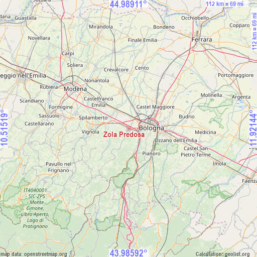
Zola Predosa GPS coordinates[2]
44° 29' 22.812" North, 11° 13' 5.916" East
| Map corner | latitude | longitude |
|---|---|---|
| Upper-left | 44.98911°, | 10.51519° |
| Center: | 44.48967°, | 11.21831° |
| Lower-right: | 43.98592°, | 11.92144° |
| Map W x H: | 111.5×111.5 km | = 69.3×69.3mi |
| max Lat: | 47.04031° ⇑49.1% North |
| Zola Predosa: | 44.48967° |
| min Lat: | ⇓50.9% South 35.50142° |
| min Long | Zola Predosa | max Long |
| 6.69888° | 11.21831° | 18.48682° |
| W 45.8%⇐ | ⇒54.2% E |
Elevation
Elevation of Zola Predosa is 82 m = 269 ft, and this is 224.7 m = 737 ft below average elevation for this country.
| Max E: |
2085 m = 6841 ft | 73.3% |
| Avg. | 306.7 m = 1006 ft | |
| Zola Predosa | 82 m = 269 ft | |
Min E: |
-4 m = -13 ft | 26.7% |
See also: Italy elevation on elevation.city.
Geographical zone
Zola Predosa is located in North temperate zone (between Tropic of Cancer and the Arctic Circle). Distance of this Northern Tropic circle is 2340.9 km =1454.6 mi to South.| Distance of | km | miles | from Zola Predosa |
|---|---|---|---|
| North Pole | 5060.3 | 3144.3 | to North |
| Arctic Circle | 2454.4 | 1525.1 | to North |
| Tropic Cancer | 2340.9 | 1454.6 | to South |
| Equator | 4946.8 | 3073.8 | to South |


Nearby cities:
15 places around Zola Predosa: (largest is in red/bold)
• Anzola dell'Emilia
5.9 km =3.7 mi,  350°
350°
• Bazzano
10.5 km =6.5 mi,  277°
277°
• Bologna
9.6 km =6 mi,  87°
87°
• Borgonuovo
7.3 km =4.5 mi,  145°
145°
• Calcara
9.3 km =5.8 mi,  313°
313°
• Calderara di Reno
9.2 km =5.7 mi,  27°
27°
• Calderino
3.9 km =2.4 mi,  203°
203°
• Casalecchio di Reno
4.8 km =3 mi,  109°
109°
• Crespellano
7.3 km =4.5 mi,  289°
289°
• Monte San Giovanni
8.6 km =5.3 mi,  205°
205°
• Ponte Ronca
2.6 km =1.6 mi,  300°
300°
• Riale
1.4 km =0.9 mi,  120°
120°
• San Vitale Grande
8.6 km =5.3 mi,  41°
41°
• Sasso Marconi
10.2 km =6.3 mi,  164°
164°
• Stiore
8.2 km =5.1 mi,  257°
257°
Sources, notices
• [Note1] Compared only with cities in Italy existing in our database
• [Src1] Map data: © OpenStreetMap contributors (CC-BY-SA)
• [Src2] Other city data from geonames.org with taken over terms of usage.
• [Src3] Geographical zone / Annual Mean Temperature by Robert A. Rohde @ Wikipedia
