Calcara geodata
Calcara (Emilia-Romagna) is a populated place; located in Italy in Europe/Rome (GMT+2) time zone. With population of 2,370 people, there are 3673 cities with bigger population in this country. Compared to other cities in Italy, 51.7% of cities are located further ↓South; 55.4% of cities are located further →East and 79.6% of cities have higher elevation than Calcara. Note1


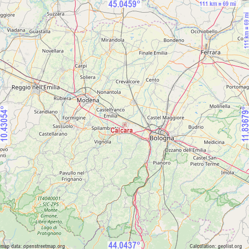
Calcara GPS coordinates[2]
44° 32' 49.056" North, 11° 8' 1.176" East
| Map corner | latitude | longitude |
|---|---|---|
| Upper-left | 45.0459°, | 10.43054° |
| Center: | 44.54696°, | 11.13366° |
| Lower-right: | 44.0437°, | 11.83679° |
| Map W x H: | 111.4×111.4 km | = 69.2×69.2mi |
| max Lat: | 47.04031° ⇑48.3% North |
| Calcara: | 44.54696° |
| min Lat: | ⇓51.7% South 35.50142° |
| min Long | Calcara | max Long |
| 6.69888° | 11.13366° | 18.48682° |
| W 44.6%⇐ | ⇒55.4% E |
Elevation
Elevation of Calcara is 52 m = 171 ft, and this is 254.7 m = 836 ft below average elevation for this country.
| Max E: |
2085 m = 6841 ft | 79.6% |
| Avg. | 306.7 m = 1006 ft | |
| Calcara | 52 m = 171 ft | |
Min E: |
-4 m = -13 ft | 20.4% |
See also: Italy elevation on elevation.city.
Geographical zone
Calcara is located in North temperate zone (between Tropic of Cancer and the Arctic Circle). Distance of this Northern Tropic circle is 2347.2 km =1458.5 mi to South.| Distance of | km | miles | from Calcara |
|---|---|---|---|
| North Pole | 5053.9 | 3140.3 | to North |
| Arctic Circle | 2448 | 1521.1 | to North |
| Tropic Cancer | 2347.2 | 1458.5 | to South |
| Equator | 4953.2 | 3077.8 | to South |


Nearby cities:
15 places around Calcara: (largest is in red/bold)
• Anzola dell'Emilia
5.7 km =3.5 mi,  95°
95°
• Bazzano
6.3 km =3.9 mi,  216°
216°
• Budrie
6.2 km =3.9 mi,  37°
37°
• Castelfranco Emilia
8.5 km =5.3 mi,  308°
308°
• Cavazzona
3.1 km =1.9 mi,  338°
338°
• Crespellano
3.9 km =2.4 mi,  181°
181°
• Manzolino
6.1 km =3.8 mi,  333°
333°
• Mulino
9.2 km =5.7 mi,  228°
228°
• Osteria Nuova
9.2 km =5.7 mi,  63°
63°
• Piumazzo
5.3 km =3.3 mi,  269°
269°
• Ponte Ronca
6.7 km =4.2 mi,  138°
138°
• San Cesario sul Panaro
8 km =5 mi,  283°
283°
• San Giacomo del Martignone
8.8 km =5.5 mi,  48°
48°
• Stiore
8.3 km =5.2 mi,  189°
189°
• Zola Predosa
9.3 km =5.8 mi,  133°
133°
Sources, notices
• [Note1] Compared only with cities in Italy existing in our database
• [Src1] Map data: © OpenStreetMap contributors (CC-BY-SA)
• [Src2] Other city data from geonames.org with taken over terms of usage.
• [Src3] Geographical zone / Annual Mean Temperature by Robert A. Rohde @ Wikipedia
