Monte San Giovanni geodata
Monte San Giovanni (Emilia-Romagna) is a populated place; located in Italy in Europe/Rome (GMT+2) time zone. With population of 1,382 people, there are 5402 cities with bigger population in this country. Compared to other cities in Italy, 50.1% of cities are located further ↑North; 54.8% of cities are located further →East and 60% of cities have higher elevation than Monte San Giovanni. Note1


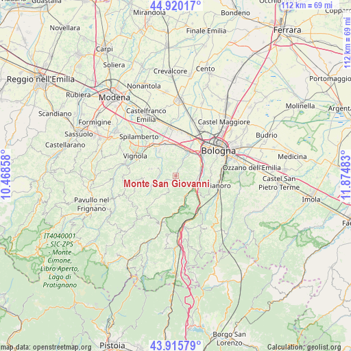
Monte San Giovanni GPS coordinates[2]
44° 25' 12.504" North, 11° 10' 18.12" East
| Map corner | latitude | longitude |
|---|---|---|
| Upper-left | 44.92017°, | 10.46858° |
| Center: | 44.42014°, | 11.1717° |
| Lower-right: | 43.91579°, | 11.87483° |
| Map W x H: | 111.7×111.7 km | = 69.4×69.4mi |
| max Lat: | 47.04031° ⇑50.1% North |
| Monte San Giovanni: | 44.42014° |
| min Lat: | ⇓49.9% South 35.50142° |
| min Long | Monte San Giova | max Long |
| 6.69888° | 11.1717° | 18.48682° |
| W 45.2%⇐ | ⇒54.8% E |
Elevation
Elevation of Monte San Giovanni is 163 m = 535 ft, and this is 143.7 m = 471 ft below average elevation for this country.
| Max E: |
2085 m = 6841 ft | 60% |
| Avg. | 306.7 m = 1006 ft | |
| Monte San Giovanni | 163 m = 535 ft | |
Min E: |
-4 m = -13 ft | 40% |
See also: Italy elevation on elevation.city.
Geographical zone
Monte San Giovanni is located in North temperate zone (between Tropic of Cancer and the Arctic Circle). Distance of this Northern Tropic circle is 2333.1 km =1449.7 mi to South.| Distance of | km | miles | from Monte San Giovanni |
|---|---|---|---|
| North Pole | 5068 | 3149.1 | to North |
| Arctic Circle | 2462.1 | 1529.9 | to North |
| Tropic Cancer | 2333.1 | 1449.7 | to South |
| Equator | 4939.1 | 3069 | to South |


Nearby cities:
15 places around Monte San Giovanni: (largest is in red/bold)
• Borgonuovo
8 km =5 mi,  77°
77°
• Calderino
4.7 km =2.9 mi,  27°
27°
• Casalecchio di Reno
10.3 km =6.4 mi,  53°
53°
• Castelletto
8.8 km =5.5 mi,  284°
284°
• Fontana
6.6 km =4.1 mi,  127°
127°
• Lama di Reno
6.9 km =4.3 mi,  148°
148°
• Marzabotto
9 km =5.6 mi,  162°
162°
• Montepastore
6.9 km =4.3 mi,  213°
213°
• Pian di Venola
9.8 km =6.1 mi,  172°
172°
• Ponte Ronca
9.2 km =5.7 mi,  8°
8°
• Riale
8.6 km =5.3 mi, 34°
• Sasso Marconi
6.7 km =4.2 mi,  108°
108°
• Savigno
8.3 km =5.2 mi,  247°
247°
• Stiore
7.4 km =4.6 mi,  323°
323°
• Zola Predosa
8.6 km =5.3 mi, 25°
Sources, notices
• [Note1] Compared only with cities in Italy existing in our database
• [Src1] Map data: © OpenStreetMap contributors (CC-BY-SA)
• [Src2] Other city data from geonames.org with taken over terms of usage.
• [Src3] Geographical zone / Annual Mean Temperature by Robert A. Rohde @ Wikipedia
