Muccia geodata
Muccia (The Marches) is a seat of a third-order administrative division; located in Italy in Europe/Rome (GMT+2) time zone. With population of 590 people, there are 9093 cities with bigger population in this country. Compared to other cities in Italy, 62.7% of cities are located further ↑North; 68.8% of cities are located further ←West and 75.6% of cities have lower elevation than Muccia. Note1


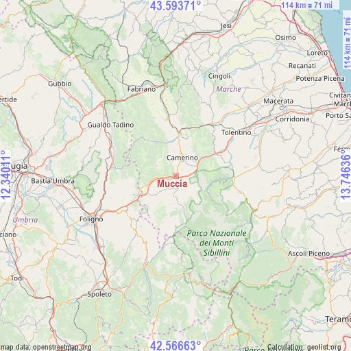
Muccia GPS coordinates[2]
43° 4' 56.352" North, 13° 2' 35.628" East
| Map corner | latitude | longitude |
|---|---|---|
| Upper-left | 43.59371°, | 12.34011° |
| Center: | 43.08232°, | 13.04323° |
| Lower-right: | 42.56663°, | 13.74636° |
| Map W x H: | 114.2×114.2 km | = 71×71mi |
| max Lat: | 47.04031° ⇑62.7% North |
| Muccia: | 43.08232° |
| min Lat: | ⇓37.3% South 35.50142° |
| min Long | Muccia | max Long |
| 6.69888° | 13.04323° | 18.48682° |
| W 68.8%⇐ | ⇒31.2% E |
Elevation
Elevation of Muccia is 460 m = 1509 ft, and this is 153.3 m = 503 ft above average elevation for this country.
| Max E: |
2085 m = 6841 ft | 24.4% |
| Muccia | 460 m 1509 ft | |
| Avg. | 306.7 m = 1006 ft | |
Min E: |
-4 m = -13 ft | 75.6% |
See also: Italy elevation on elevation.city.
Geographical zone
Muccia is located in North temperate zone (between Tropic of Cancer and the Arctic Circle). Distance of this Northern Tropic circle is 2184.4 km =1357.3 mi to South.| Distance of | km | miles | from Muccia |
|---|---|---|---|
| North Pole | 5216.8 | 3241.6 | to North |
| Arctic Circle | 2610.9 | 1622.3 | to North |
| Tropic Cancer | 2184.4 | 1357.3 | to South |
| Equator | 4790.3 | 2976.6 | to South |


Nearby cities:
15 places around Muccia: (largest is in red/bold)
• Caldarola
16.1 km =10 mi,  65°
65°
• Camerino
6.6 km =4.1 mi,  17°
17°
• Castelraimondo
14.1 km =8.8 mi,  3°
3°
• Massa
14.8 km =9.2 mi,  322°
322°
• Pie' del Colle
12.2 km =7.6 mi,  118°
118°
• Pie' del Sasso
10.4 km =6.5 mi,  200°
200°
• Pieve Torina
4.4 km =2.7 mi,  175°
175°
• Pievebovigliana
3.9 km =2.4 mi, 123°
• Pioraco
12.2 km =7.6 mi,  333°
333°
• Sefro
10.6 km =6.6 mi,  313°
313°
• Serrapetrona
15.9 km =9.9 mi,  48°
48°
• Serravalle di Chienti
7.5 km =4.7 mi,  261°
261°
• Trebbio
10.3 km =6.4 mi, 119°
• Valle e Castello
6.2 km =3.9 mi,  144°
144°
• Visso
16.8 km =10.4 mi,  169°
169°
Sources, notices
• [Note1] Compared only with cities in Italy existing in our database
• [Src1] Map data: © OpenStreetMap contributors (CC-BY-SA)
• [Src2] Other city data from geonames.org with taken over terms of usage.
• [Src3] Geographical zone / Annual Mean Temperature by Robert A. Rohde @ Wikipedia
