Alfero geodata
Alfero (Emilia-Romagna) is a populated place; located in Italy in Europe/Rome (GMT+2) time zone. With population of 658 people, there are 8573 cities with bigger population in this country. Compared to other cities in Italy, 56.4% of cities are located further ↑North; 56.7% of cities are located further ←West and 88.1% of cities have lower elevation than Alfero. Note1
Administrative division(s):
- Level 1: Emilia-Romagna
- Level 2: Provincia di Forlì-Cesena
- Level 3: Verghereto


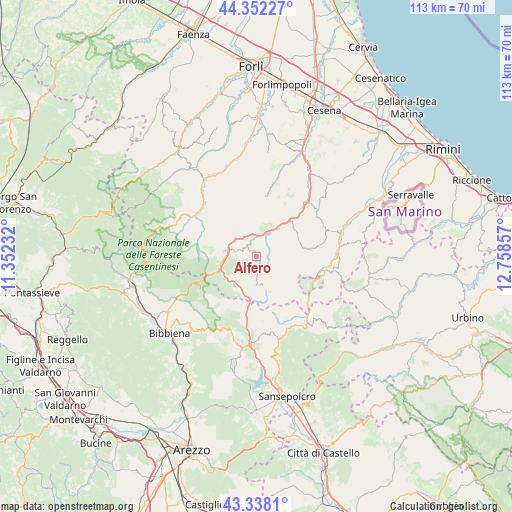
Alfero GPS coordinates[2]
43° 50' 50.424" North, 12° 3' 19.584" East
| Map corner | latitude | longitude |
|---|---|---|
| Upper-left | 44.35227°, | 11.35232° |
| Center: | 43.84734°, | 12.05544° |
| Lower-right: | 43.3381°, | 12.75857° |
| Map W x H: | 112.8×112.8 km | = 70.1×70.1mi |
| max Lat: | 47.04031° ⇑56.4% North |
| Alfero: | 43.84734° |
| min Lat: | ⇓43.6% South 35.50142° |
| min Long | Alfero | max Long |
| 6.69888° | 12.05544° | 18.48682° |
| W 56.7%⇐ | ⇒43.3% E |
Elevation
Elevation of Alfero is 675 m = 2215 ft, and this is 368.3 m = 1208 ft above average elevation for this country.
| Max E: |
2085 m = 6841 ft | 11.9% |
| Alfero | 675 m 2215 ft | |
| Avg. | 306.7 m = 1006 ft | |
Min E: |
-4 m = -13 ft | 88.1% |
See also: Italy elevation on elevation.city.
Geographical zone
Alfero is located in North temperate zone (between Tropic of Cancer and the Arctic Circle). Distance of this Northern Tropic circle is 2269.4 km =1410.1 mi to South.| Distance of | km | miles | from Alfero |
|---|---|---|---|
| North Pole | 5131.7 | 3188.7 | to North |
| Arctic Circle | 2525.8 | 1569.5 | to North |
| Tropic Cancer | 2269.4 | 1410.1 | to South |
| Equator | 4875.4 | 3029.4 | to South |


Nearby cities:
15 places around Alfero: (largest is in red/bold)
• Badia Prataglia
15.4 km =9.6 mi,  247°
247°
• Badia Tedalda
18.5 km =11.5 mi,  146°
146°
• Bagno di Romagna
7.8 km =4.8 mi,  260°
260°
• Casteldelci
10.1 km =6.3 mi,  127°
127°
• Chiusi della Verna
19.3 km =12 mi,  210°
210°
• Mercato Saraceno
17.1 km =10.6 mi,  41°
41°
• Monte Castello
15.3 km =9.5 mi, 42°
• Novafeltria
19.4 km =12.1 mi,  74°
74°
• Pennabilli
17.3 km =10.7 mi,  101°
101°
• Perticara
16.3 km =10.1 mi, 66°
• San Piero in Bagno
6.4 km =4 mi,  280°
280°
• Sant'Agata Feltria
12.3 km =7.6 mi,  81°
81°
• Santa Sofia
16.2 km =10.1 mi,  313°
313°
• Sarsina
10.7 km =6.6 mi, 40°
• Verghereto
7.1 km =4.4 mi, 214°
Sources, notices
• [Note1] Compared only with cities in Italy existing in our database
• [Src1] Map data: © OpenStreetMap contributors (CC-BY-SA)
• [Src2] Other city data from geonames.org with taken over terms of usage.
• [Src3] Geographical zone / Annual Mean Temperature by Robert A. Rohde @ Wikipedia
