Terlago geodata
Terlago (Trentino-Alto Adige) is a seat of a third-order administrative division; located in Italy in Europe/Rome (GMT+2) time zone. With population of 838 people, there are 7457 cities with bigger population in this country. Compared to other cities in Italy, 94% of cities are located further ↓South; 56.6% of cities are located further →East and 75.6% of cities have lower elevation than Terlago. Note1
Administrative division(s):
- Level 1: Trentino-Alto Adige
- Level 2: Provincia autonoma di Trento
- Level 3: Vallelaghi


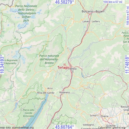
Terlago GPS coordinates[2]
46° 5' 50.532" North, 11° 2' 42.18" East
| Map corner | latitude | longitude |
|---|---|---|
| Upper-left | 46.58279°, | 10.34193° |
| Center: | 46.09737°, | 11.04505° |
| Lower-right: | 45.60764°, | 11.74818° |
| Map W x H: | 108.4×108.4 km | = 67.4×67.4mi |
| max Lat: | 47.04031° ⇑6% North |
| Terlago: | 46.09737° |
| min Lat: | ⇓94% South 35.50142° |
| min Long | Terlago | max Long |
| 6.69888° | 11.04505° | 18.48682° |
| W 43.4%⇐ | ⇒56.6% E |
Elevation
Elevation of Terlago is 460 m = 1509 ft, and this is 153.3 m = 503 ft above average elevation for this country.
| Max E: |
2085 m = 6841 ft | 24.4% |
| Terlago | 460 m 1509 ft | |
| Avg. | 306.7 m = 1006 ft | |
Min E: |
-4 m = -13 ft | 75.6% |
See also: Italy elevation on elevation.city.
Geographical zone
Terlago is located in North temperate zone (between Tropic of Cancer and the Arctic Circle). Distance of this North polar circle is 2275.6 km =1414 mi to North.| Distance of | km | miles | from Terlago |
|---|---|---|---|
| North Pole | 4881.5 | 3033.2 | to North |
| Arctic Circle | 2275.6 | 1414 | to North |
| Tropic Cancer | 2519.6 | 1565.6 | to South |
| Equator | 5125.5 | 3184.8 | to South |


Nearby cities:
15 places around Terlago: (largest is in red/bold)
• Cadine
2 km =1.2 mi,  115°
115°
• Calavino
7.4 km =4.6 mi,  219°
219°
• Gazzadina
7.3 km =4.5 mi,  61°
61°
• Lavis
7 km =4.3 mi,  45°
45°
• Meano
6.4 km =4 mi, 61°
• Molveno
8.1 km =5 mi,  308°
308°
• Padergnone
6.2 km =3.9 mi,  228°
228°
• Pressano
7.7 km =4.8 mi,  37°
37°
• Ravina
8.3 km =5.2 mi,  141°
141°
• Sardagna
5.4 km =3.4 mi,  133°
133°
• Trento
6.7 km =4.2 mi, 119°
• Vela
4.7 km =2.9 mi,  110°
110°
• Vezzano
4.2 km =2.6 mi,  240°
240°
• Vigo Meano
7.9 km =4.9 mi, 59°
• Zambana
7.2 km =4.5 mi,  33°
33°
Sources, notices
• [Note1] Compared only with cities in Italy existing in our database
• [Src1] Map data: © OpenStreetMap contributors (CC-BY-SA)
• [Src2] Other city data from geonames.org with taken over terms of usage.
• [Src3] Geographical zone / Annual Mean Temperature by Robert A. Rohde @ Wikipedia
