Varsi geodata
Varsi (Emilia-Romagna) is a seat of a third-order administrative division; located in Italy in Europe/Rome (GMT+2) time zone. With population of 492 people, there are 9957 cities with bigger population in this country. Compared to other cities in Italy, 53.5% of cities are located further ↓South; 69.4% of cities are located further →East and 74.8% of cities have lower elevation than Varsi. Note1


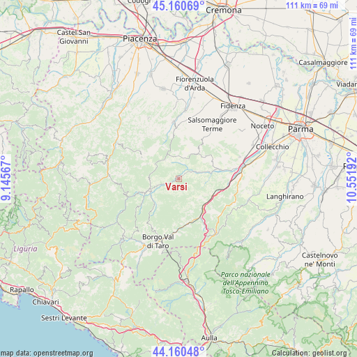
Varsi GPS coordinates[2]
44° 39' 45.864" North, 9° 50' 55.644" East
| Map corner | latitude | longitude |
|---|---|---|
| Upper-left | 45.16069°, | 9.14567° |
| Center: | 44.66274°, | 9.84879° |
| Lower-right: | 44.16048°, | 10.55192° |
| Map W x H: | 111.2×111.2 km | = 69.1×69.1mi |
| max Lat: | 47.04031° ⇑46.5% North |
| Varsi: | 44.66274° |
| min Lat: | ⇓53.5% South 35.50142° |
| min Long | Varsi | max Long |
| 6.69888° | 9.84879° | 18.48682° |
| W 30.6%⇐ | ⇒69.4% E |
Elevation
Elevation of Varsi is 449 m = 1473 ft, and this is 142.3 m = 467 ft above average elevation for this country.
| Max E: |
2085 m = 6841 ft | 25.2% |
| Varsi | 449 m 1473 ft | |
| Avg. | 306.7 m = 1006 ft | |
Min E: |
-4 m = -13 ft | 74.8% |
See also: Italy elevation on elevation.city.
Geographical zone
Varsi is located in North temperate zone (between Tropic of Cancer and the Arctic Circle). Distance of this Northern Tropic circle is 2360.1 km =1466.5 mi to South.| Distance of | km | miles | from Varsi |
|---|---|---|---|
| North Pole | 5041 | 3132.3 | to North |
| Arctic Circle | 2435.1 | 1513.1 | to North |
| Tropic Cancer | 2360.1 | 1466.5 | to South |
| Equator | 4966 | 3085.7 | to South |


Nearby cities:
15 places around Varsi: (largest is in red/bold)
• Bardi
10.1 km =6.3 mi,  249°
249°
• Bore
7.7 km =4.8 mi,  324°
324°
• Fornovo di Taro
20.3 km =12.6 mi,  79°
79°
• Lugagnano Val d'Arda
17.9 km =11.1 mi,  354°
354°
• Morfasso
13.4 km =8.3 mi,  299°
299°
• Pellegrino Parmense
9.9 km =6.2 mi,  41°
41°
• Ramiola
19.6 km =12.2 mi, 77°
• Salita-Riola
19.7 km =12.2 mi,  85°
85°
• Salsomaggiore Terme
20.2 km =12.6 mi,  32°
32°
• Sant'Andrea Bagni
20.1 km =12.5 mi,  70°
70°
• Solignano
11.4 km =7.1 mi,  118°
118°
• Stazione Valmozzola
11.9 km =7.4 mi,  141°
141°
• Terenzo
19.9 km =12.4 mi,  106°
106°
• Varano De' Melegari
13.2 km =8.2 mi, 77°
• Vernasca
15.2 km =9.4 mi, 354°
Sources, notices
• [Note1] Compared only with cities in Italy existing in our database
• [Src1] Map data: © OpenStreetMap contributors (CC-BY-SA)
• [Src2] Other city data from geonames.org with taken over terms of usage.
• [Src3] Geographical zone / Annual Mean Temperature by Robert A. Rohde @ Wikipedia
