Cesolo geodata
Cesolo (The Marches) is a populated place; located in Italy in Europe/Rome (GMT+2) time zone. With population of 527 people, there are 9666 cities with bigger population in this country. Compared to other cities in Italy, 61.4% of cities are located further ↑North; 70.3% of cities are located further ←West and 55.4% of cities have lower elevation than Cesolo. Note1
Administrative division(s):
- Level 1: The Marches
- Level 2: Provincia di Macerata
- Level 3: San Severino Marche


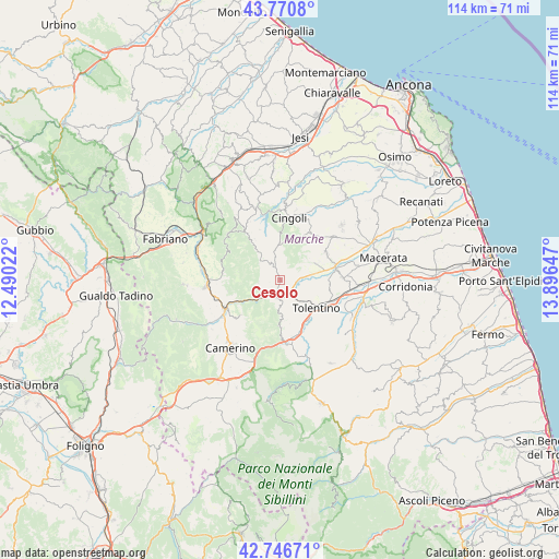
Cesolo GPS coordinates[2]
43° 15' 39.276" North, 13° 11' 36.024" East
| Map corner | latitude | longitude |
|---|---|---|
| Upper-left | 43.7708°, | 12.49022° |
| Center: | 43.26091°, | 13.19334° |
| Lower-right: | 42.74671°, | 13.89647° |
| Map W x H: | 113.9×113.9 km | = 70.8×70.8mi |
| max Lat: | 47.04031° ⇑61.4% North |
| Cesolo: | 43.26091° |
| min Lat: | ⇓38.6% South 35.50142° |
| min Long | Cesolo | max Long |
| 6.69888° | 13.19334° | 18.48682° |
| W 70.3%⇐ | ⇒29.7% E |
Elevation
Elevation of Cesolo is 268 m = 879 ft, and this is 38.7 m = 127 ft below average elevation for this country.
| Max E: |
2085 m = 6841 ft | 44.6% |
| Avg. | 306.7 m = 1006 ft | |
| Cesolo | 268 m = 879 ft | |
Min E: |
-4 m = -13 ft | 55.4% |
See also: Italy elevation on elevation.city.
Geographical zone
Cesolo is located in North temperate zone (between Tropic of Cancer and the Arctic Circle). Distance of this Northern Tropic circle is 2204.2 km =1369.6 mi to South.| Distance of | km | miles | from Cesolo |
|---|---|---|---|
| North Pole | 5196.9 | 3229.2 | to North |
| Arctic Circle | 2591 | 1610 | to North |
| Tropic Cancer | 2204.2 | 1369.6 | to South |
| Equator | 4810.2 | 2988.9 | to South |


Nearby cities:
15 places around Cesolo: (largest is in red/bold)
• Belforte del Chienti
11.5 km =7.1 mi,  159°
159°
• Caldarola
13.4 km =8.3 mi,  169°
169°
• Castelraimondo
12.6 km =7.8 mi,  242°
242°
• Chiesanuova
13.8 km =8.6 mi,  51°
51°
• Cingoli
12.8 km =8 mi,  5°
5°
• Gagliole
10.5 km =6.5 mi,  256°
256°
• Grottaccia
11.4 km =7.1 mi,  34°
34°
• Matelica
15.1 km =9.4 mi,  268°
268°
• Passo di Treia
11.6 km =7.2 mi,  75°
75°
• Pollenza
12.5 km =7.8 mi,  87°
87°
• San Severino Marche
3.6 km =2.2 mi,  197°
197°
• Serrapetrona
9.4 km =5.8 mi,  181°
181°
• Tolentino
9.4 km =5.8 mi,  127°
127°
• Treia
10.8 km =6.7 mi,  60°
60°
• Troviggiano
13.9 km =8.6 mi,  19°
19°
Sources, notices
• [Note1] Compared only with cities in Italy existing in our database
• [Src1] Map data: © OpenStreetMap contributors (CC-BY-SA)
• [Src2] Other city data from geonames.org with taken over terms of usage.
• [Src3] Geographical zone / Annual Mean Temperature by Robert A. Rohde @ Wikipedia
