Agello geodata
Agello (Umbria) is a populated place; located in Italy in Europe/Rome (GMT+2) time zone. With population of 909 people, there are 7095 cities with bigger population in this country. Compared to other cities in Italy, 62.8% of cities are located further ↑North; 59.2% of cities are located further ←West and 67.9% of cities have lower elevation than Agello. Note1


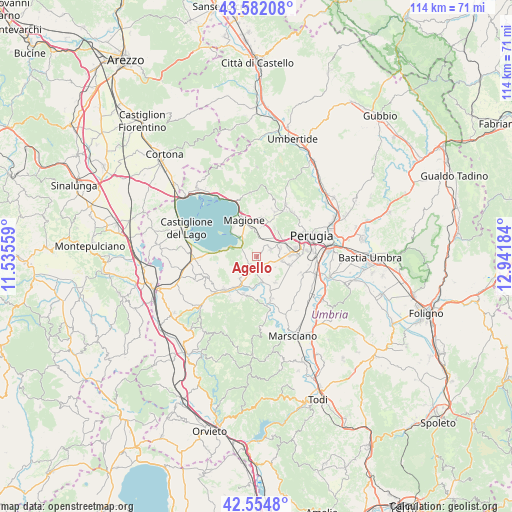
Agello GPS coordinates[2]
43° 4' 14.124" North, 12° 14' 19.356" East
| Map corner | latitude | longitude |
|---|---|---|
| Upper-left | 43.58208°, | 11.53559° |
| Center: | 43.07059°, | 12.23871° |
| Lower-right: | 42.5548°, | 12.94184° |
| Map W x H: | 114.2×114.2 km | = 71×71mi |
| max Lat: | 47.04031° ⇑62.8% North |
| Agello: | 43.07059° |
| min Lat: | ⇓37.2% South 35.50142° |
| min Long | Agello | max Long |
| 6.69888° | 12.23871° | 18.48682° |
| W 59.2%⇐ | ⇒40.8% E |
Elevation
Elevation of Agello is 373 m = 1224 ft, and this is 66.3 m = 218 ft above average elevation for this country.
| Max E: |
2085 m = 6841 ft | 32.1% |
| Agello | 373 m 1224 ft | |
| Avg. | 306.7 m = 1006 ft | |
Min E: |
-4 m = -13 ft | 67.9% |
See also: Italy elevation on elevation.city.
Geographical zone
Agello is located in North temperate zone (between Tropic of Cancer and the Arctic Circle). Distance of this Northern Tropic circle is 2183.1 km =1356.5 mi to South.| Distance of | km | miles | from Agello |
|---|---|---|---|
| North Pole | 5218.1 | 3242.4 | to North |
| Arctic Circle | 2612.2 | 1623.1 | to North |
| Tropic Cancer | 2183.1 | 1356.5 | to South |
| Equator | 4789 | 2975.7 | to South |


Nearby cities:
15 places around Agello: (largest is in red/bold)
• Castiglione della Valle
5.7 km =3.5 mi,  169°
169°
• Chiugiana-La Commenda
6.4 km =4 mi,  61°
61°
• Corciano
7.5 km =4.7 mi,  31°
31°
• Fontignano
6.4 km =4 mi,  216°
216°
• Il Rigo
6.2 km =3.9 mi,  53°
53°
• Lacugnano
8 km =5 mi,  70°
70°
• Magione
8.2 km =5.1 mi,  344°
344°
• Mugnano
2.3 km =1.4 mi, 222°
• Pila
7.5 km =4.7 mi,  104°
104°
• San Biagio della Valle
6.9 km =4.3 mi,  144°
144°
• San Feliciano
7.8 km =4.8 mi,  312°
312°
• San Pietro
6.3 km =3.9 mi, 31°
• San Savino
5.6 km =3.5 mi,  318°
318°
• Sant'Arcangelo
6.7 km =4.2 mi,  283°
283°
• Soccorso
7.6 km =4.7 mi,  359°
359°
Sources, notices
• [Note1] Compared only with cities in Italy existing in our database
• [Src1] Map data: © OpenStreetMap contributors (CC-BY-SA)
• [Src2] Other city data from geonames.org with taken over terms of usage.
• [Src3] Geographical zone / Annual Mean Temperature by Robert A. Rohde @ Wikipedia
