Castiglione della Valle geodata
Castiglione della Valle (Umbria) is a populated place; located in Italy in Europe/Rome (GMT+2) time zone. With population of 527 people, there are 9666 cities with bigger population in this country. Compared to other cities in Italy, 63.3% of cities are located further ↑North; 59.3% of cities are located further ←West and 53.2% of cities have higher elevation than Castiglione della Valle. Note1
Current local time in Castiglione della Valle:
06:57 PM, WednesdayDifference from your time zone: hours


Castiglione della Valle GPS coordinates[2]
43° 1' 11.892" North, 12° 15' 5.364" East
| Map corner | latitude | longitude |
|---|---|---|
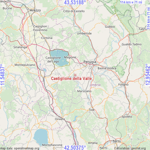
| Upper-left | 43.53188°, | 11.54837° |
| Center: | 43.01997°, | 12.25149° |
| Lower-right: | 42.50375°, | 12.95462° |
| Map W x H: | 114.3×114.3 km | = 71×71mi |
| max Lat: | 47.04031° ⇑63.3% North |
| Castiglione della Valle: | 43.01997° |
| min Lat: | ⇓36.7% South 35.50142° |
| min Long | Castiglione del | max Long |
| 6.69888° | 12.25149° | 18.48682° |
| W 59.3%⇐ | ⇒40.7% E |
Elevation
Elevation of Castiglione della Valle is 215 m = 705 ft, and this is 91.7 m = 301 ft below average elevation for this country.
| Max E: |
2085 m = 6841 ft | 53.2% |
| Avg. | 306.7 m = 1006 ft | |
| Castiglione della Valle | 215 m = 705 ft | |
Min E: |
-4 m = -13 ft | 46.8% |
See also: Italy elevation on elevation.city.
Geographical zone
Castiglione della Valle is located in North temperate zone (between Tropic of Cancer and the Arctic Circle). Distance of this Northern Tropic circle is 2177.5 km =1353 mi to South.| Distance of | km | miles | from Castiglione della Valle |
|---|---|---|---|
| North Pole | 5223.7 | 3245.9 | to North |
| Arctic Circle | 2617.8 | 1626.6 | to North |
| Tropic Cancer | 2177.5 | 1353 | to South |
| Equator | 4783.4 | 2972.3 | to South |


Nearby cities:
15 places around Castiglione della Valle: (largest is in red/bold)
• Agello
5.7 km =3.5 mi,  349°
349°
• Cerqueto
9.3 km =5.8 mi,  144°
144°
• Chiugiana-La Commenda
9.8 km =6.1 mi,  27°
27°
• Fontignano
4.9 km =3 mi,  275°
275°
• Il Rigo
10.1 km =6.3 mi,  22°
22°
• Lacugnano
10.6 km =6.6 mi,  38°
38°
• Mugnano
4.7 km =2.9 mi,  326°
326°
• Pietrafitta
4.5 km =2.8 mi,  224°
224°
• Pila
7.3 km =4.5 mi,  59°
59°
• San Biagio della Valle
3 km =1.9 mi,  88°
88°
• San Niccolò di Celle
10.7 km =6.6 mi, 91°
• Sant'Arcangelo
10.4 km =6.5 mi,  313°
313°
• Sant'Enea
8.7 km =5.4 mi,  97°
97°
• Spina
4.5 km =2.8 mi,  148°
148°
• Tavernelle
8.8 km =5.5 mi,  257°
257°
Sources, notices
• [Note1] Compared only with cities in Italy existing in our database
• [Src1] Map data: © OpenStreetMap contributors (CC-BY-SA)
• [Src2] Other city data from geonames.org with taken over terms of usage.
• [Src3] Geographical zone / Annual Mean Temperature by Robert A. Rohde @ Wikipedia
