Sigillo geodata
Sigillo (Umbria) is a seat of a third-order administrative division; located in Italy in Europe/Rome (GMT+1) time zone. With population of 2,192 people, there are 3882 cities with bigger population in this country. Compared to other cities in Italy, 60.9% of cities are located further ↑North; 65.5% of cities are located further ←West and 77.5% of cities have lower elevation than Sigillo. Note1


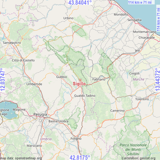
Sigillo GPS coordinates[2]
43° 19' 51.996" North, 12° 44' 26.124" East
| Map corner | latitude | longitude |
|---|---|---|
| Upper-left | 43.84041°, | 12.03747° |
| Center: | 43.33111°, | 12.74059° |
| Lower-right: | 42.8175°, | 13.44372° |
| Map W x H: | 113.7×113.7 km | = 70.6×70.6mi |
| max Lat: | 47.04031° ⇑60.9% North |
| Sigillo: | 43.33111° |
| min Lat: | ⇓39.1% South 35.50142° |
| min Long | Sigillo | max Long |
| 6.69888° | 12.74059° | 18.48682° |
| W 65.5%⇐ | ⇒34.5% E |
Elevation
Elevation of Sigillo is 486 m = 1594 ft, and this is 179.3 m = 588 ft above average elevation for this country.
| Max E: |
2085 m = 6841 ft | 22.5% |
| Sigillo | 486 m 1594 ft | |
| Avg. | 306.7 m = 1006 ft | |
Min E: |
-4 m = -13 ft | 77.5% |
See also: Italy elevation on elevation.city.
Geographical zone
Sigillo is located in North temperate zone (between Tropic of Cancer and the Arctic Circle). Distance of this Northern Tropic circle is 2212 km =1374.5 mi to South.| Distance of | km | miles | from Sigillo |
|---|---|---|---|
| North Pole | 5189.1 | 3224.4 | to North |
| Arctic Circle | 2583.2 | 1605.1 | to North |
| Tropic Cancer | 2212 | 1374.5 | to South |
| Equator | 4818 | 2993.8 | to South |


Nearby cities:
15 places around Sigillo: (largest is in red/bold)
• Branca
8 km =5 mi,  216°
216°
• Casanova di Torre
7.8 km =4.8 mi,  236°
236°
• Cerqueto
11 km =6.8 mi,  176°
176°
• Cipolleto
13.3 km =8.3 mi,  266°
266°
• Costacciaro
3.8 km =2.4 mi,  323°
323°
• Fabriano
13.2 km =8.2 mi,  85°
85°
• Fossato di Vico
4.2 km =2.6 mi,  156°
156°
• Gualdo Tadino
11.7 km =7.3 mi, 164°
• Marischio
10.4 km =6.5 mi,  84°
84°
• Osteria del Gatto
5.1 km =3.2 mi, 175°
• Padule-San Marco
10.6 km =6.6 mi, 268°
• Palazzo Mancinelli-Vaccara
8.2 km =5.1 mi,  167°
167°
• Purello
2.1 km =1.3 mi,  139°
139°
• Scheggia
10.1 km =6.3 mi, 323°
• Stazione di Padule
10.4 km =6.5 mi,  255°
255°
Sources, notices
• [Note1] Compared only with cities in Italy existing in our database
• [Src1] Map data: © OpenStreetMap contributors (CC-BY-SA)
• [Src2] Other city data from geonames.org with taken over terms of usage.
• [Src3] Geographical zone / Annual Mean Temperature by Robert A. Rohde @ Wikipedia
