Stazione di Padule geodata
Stazione di Padule (Umbria) is a populated place; located in Italy in Europe/Rome (GMT+2) time zone. With population of 1,014 people, there are 6608 cities with bigger population in this country. Compared to other cities in Italy, 61.1% of cities are located further ↑North; 63.8% of cities are located further ←West and 71.8% of cities have lower elevation than Stazione di Padule. Note1


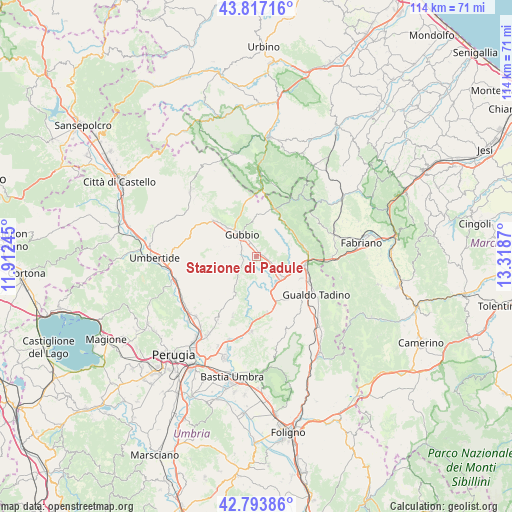
Stazione di Padule GPS coordinates[2]
43° 18' 27.576" North, 12° 36' 56.052" East
| Map corner | latitude | longitude |
|---|---|---|
| Upper-left | 43.81716°, | 11.91245° |
| Center: | 43.30766°, | 12.61557° |
| Lower-right: | 42.79386°, | 13.3187° |
| Map W x H: | 113.8×113.8 km | = 70.7×70.7mi |
| max Lat: | 47.04031° ⇑61.1% North |
| Stazione di Padule: | 43.30766° |
| min Lat: | ⇓38.9% South 35.50142° |
| min Long | Stazione di Pad | max Long |
| 6.69888° | 12.61557° | 18.48682° |
| W 63.8%⇐ | ⇒36.2% E |
Elevation
Elevation of Stazione di Padule is 413 m = 1355 ft, and this is 106.3 m = 349 ft above average elevation for this country.
| Max E: |
2085 m = 6841 ft | 28.2% |
| Stazione di Padule | 413 m 1355 ft | |
| Avg. | 306.7 m = 1006 ft | |
Min E: |
-4 m = -13 ft | 71.8% |
See also: Italy elevation on elevation.city.
Geographical zone
Stazione di Padule is located in North temperate zone (between Tropic of Cancer and the Arctic Circle). Distance of this Northern Tropic circle is 2209.4 km =1372.9 mi to South.| Distance of | km | miles | from Stazione di Padule |
|---|---|---|---|
| North Pole | 5191.7 | 3226 | to North |
| Arctic Circle | 2585.8 | 1606.7 | to North |
| Tropic Cancer | 2209.4 | 1372.9 | to South |
| Equator | 4815.4 | 2992.1 | to South |


Nearby cities:
15 places around Stazione di Padule: (largest is in red/bold)
• Branca
6.5 km =4 mi,  125°
125°
• Casacastalda
12.5 km =7.8 mi,  168°
168°
• Casanova di Torre
4 km =2.5 mi,  114°
114°
• Cipolleto
3.6 km =2.2 mi,  300°
300°
• Costacciaro
9.7 km =6 mi,  54°
54°
• Fossato di Vico
11.9 km =7.4 mi,  96°
96°
• Gubbio
5.8 km =3.6 mi,  323°
323°
• Osteria del Gatto
10.8 km =6.7 mi, 103°
• Padule-San Marco
2.4 km =1.5 mi,  348°
348°
• Palazzo Mancinelli-Vaccara
13.1 km =8.1 mi, 114°
• Ponte d'Assi
3.2 km =2 mi,  275°
275°
• Purello
11.5 km =7.1 mi,  84°
84°
• Scheggia
11.4 km =7.1 mi,  20°
20°
• Semonte-Casamorcia
9.6 km =6 mi,  314°
314°
• Sigillo
10.4 km =6.5 mi, 75°
Sources, notices
• [Note1] Compared only with cities in Italy existing in our database
• [Src1] Map data: © OpenStreetMap contributors (CC-BY-SA)
• [Src2] Other city data from geonames.org with taken over terms of usage.
• [Src3] Geographical zone / Annual Mean Temperature by Robert A. Rohde @ Wikipedia
