Padule-San Marco geodata
Padule-San Marco (Umbria) is a populated place; located in Italy in Europe/Rome (GMT+2) time zone. With population of 2,413 people, there are 3625 cities with bigger population in this country. Compared to other cities in Italy, 60.9% of cities are located further ↑North; 63.7% of cities are located further ←West and 75.2% of cities have lower elevation than Padule-San Marco. Note1


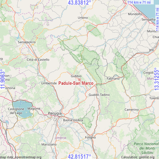
Padule-San Marco GPS coordinates[2]
43° 19' 43.68" North, 12° 36' 33.912" East
| Map corner | latitude | longitude |
|---|---|---|
| Upper-left | 43.83812°, | 11.9063° |
| Center: | 43.3288°, | 12.60942° |
| Lower-right: | 42.81517°, | 13.31255° |
| Map W x H: | 113.7×113.7 km | = 70.6×70.6mi |
| max Lat: | 47.04031° ⇑60.9% North |
| Padule-San Marco: | 43.3288° |
| min Lat: | ⇓39.1% South 35.50142° |
| min Long | Padule-San Marc | max Long |
| 6.69888° | 12.60942° | 18.48682° |
| W 63.7%⇐ | ⇒36.3% E |
Elevation
Elevation of Padule-San Marco is 454 m = 1490 ft, and this is 147.3 m = 483 ft above average elevation for this country.
| Max E: |
2085 m = 6841 ft | 24.8% |
| Padule-San Marco | 454 m 1490 ft | |
| Avg. | 306.7 m = 1006 ft | |
Min E: |
-4 m = -13 ft | 75.2% |
See also: Italy elevation on elevation.city.
Geographical zone
Padule-San Marco is located in North temperate zone (between Tropic of Cancer and the Arctic Circle). Distance of this Northern Tropic circle is 2211.8 km =1374.3 mi to South.| Distance of | km | miles | from Padule-San Marco |
|---|---|---|---|
| North Pole | 5189.4 | 3224.5 | to North |
| Arctic Circle | 2583.5 | 1605.3 | to North |
| Tropic Cancer | 2211.8 | 1374.3 | to South |
| Equator | 4817.7 | 2993.6 | to South |


Nearby cities:
15 places around Padule-San Marco: (largest is in red/bold)
• Branca
8.5 km =5.3 mi,  136°
136°
• Casacastalda
14.9 km =9.3 mi,  168°
168°
• Casanova di Torre
5.8 km =3.6 mi,  134°
134°
• Cipolleto
2.7 km =1.7 mi,  258°
258°
• Costacciaro
9 km =5.6 mi,  68°
68°
• Fossato di Vico
12.8 km =8 mi,  106°
106°
• Gubbio
3.8 km =2.4 mi,  308°
308°
• Osteria del Gatto
12 km =7.5 mi, 113°
• Palazzo Mancinelli-Vaccara
14.6 km =9.1 mi,  122°
122°
• Ponte d'Assi
3.4 km =2.1 mi,  232°
232°
• Purello
12 km =7.5 mi,  96°
96°
• Scheggia
9.5 km =5.9 mi,  28°
28°
• Semonte-Casamorcia
7.7 km =4.8 mi,  304°
304°
• Sigillo
10.6 km =6.6 mi,  88°
88°
• Stazione di Padule
2.4 km =1.5 mi, 168°
Sources, notices
• [Note1] Compared only with cities in Italy existing in our database
• [Src1] Map data: © OpenStreetMap contributors (CC-BY-SA)
• [Src2] Other city data from geonames.org with taken over terms of usage.
• [Src3] Geographical zone / Annual Mean Temperature by Robert A. Rohde @ Wikipedia
