Palazzo Mancinelli-Vaccara geodata
Palazzo Mancinelli-Vaccara (Umbria) is a populated place; located in Italy in Europe/Rome (GMT+1) time zone. With population of 718 people, there are 8166 cities with bigger population in this country. Compared to other cities in Italy, 61.4% of cities are located further ↑North; 65.7% of cities are located further ←West and 73.9% of cities have lower elevation than Palazzo Mancinelli-Vaccara. Note1
Current local time in Palazzo Mancinelli-Vaccara:
04:37 PM, ThursdayDifference from your time zone: hours


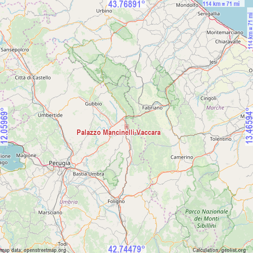
Palazzo Mancinelli-Vaccara GPS coordinates[2]
43° 15' 32.4" North, 12° 45' 46.116" East
| Map corner | latitude | longitude |
|---|---|---|
| Upper-left | 43.76891°, | 12.05969° |
| Center: | 43.259°, | 12.76281° |
| Lower-right: | 42.74479°, | 13.46594° |
| Map W x H: | 113.9×113.9 km | = 70.8×70.8mi |
| max Lat: | 47.04031° ⇑61.4% North |
| Palazzo Mancinelli-Vaccara: | 43.259° |
| min Lat: | ⇓38.6% South 35.50142° |
| min Long | Palazzo Mancine | max Long |
| 6.69888° | 12.76281° | 18.48682° |
| W 65.7%⇐ | ⇒34.3% E |
Elevation
Elevation of Palazzo Mancinelli-Vaccara is 438 m = 1437 ft, and this is 131.3 m = 431 ft above average elevation for this country.
| Max E: |
2085 m = 6841 ft | 26.1% |
| Palazzo Mancinelli-Vaccara | 438 m 1437 ft | |
| Avg. | 306.7 m = 1006 ft | |
Min E: |
-4 m = -13 ft | 73.9% |
See also: Italy elevation on elevation.city.
Geographical zone
Palazzo Mancinelli-Vaccara is located in North temperate zone (between Tropic of Cancer and the Arctic Circle). Distance of this Northern Tropic circle is 2204 km =1369.5 mi to South.| Distance of | km | miles | from Palazzo Mancinelli-Vaccara |
|---|---|---|---|
| North Pole | 5197.1 | 3229.3 | to North |
| Arctic Circle | 2591.2 | 1610.1 | to North |
| Tropic Cancer | 2204 | 1369.5 | to South |
| Equator | 4809.9 | 2988.7 | to South |


Nearby cities:
15 places around Palazzo Mancinelli-Vaccara: (largest is in red/bold)
• Branca
6.8 km =4.2 mi,  283°
283°
• Casacastalda
11.6 km =7.2 mi,  233°
233°
• Casanova di Torre
9.1 km =5.7 mi,  294°
294°
• Cerqueto
3.2 km =2 mi,  200°
200°
• Costacciaro
11.8 km =7.3 mi,  339°
339°
• Esanatoglia
15.1 km =9.4 mi,  92°
92°
• Fabriano
14.5 km =9 mi,  51°
51°
• Fossato di Vico
4.2 km =2.6 mi,  358°
358°
• Gualdo Tadino
3.5 km =2.2 mi,  158°
158°
• Marischio
12.4 km =7.7 mi,  43°
43°
• Osteria del Gatto
3.2 km =2 mi,  333°
333°
• Padule-San Marco
14.6 km =9.1 mi,  302°
302°
• Purello
6.5 km =4 mi, 356°
• Sigillo
8.2 km =5.1 mi,  347°
347°
• Stazione di Padule
13.1 km =8.1 mi, 294°
Sources, notices
• [Note1] Compared only with cities in Italy existing in our database
• [Src1] Map data: © OpenStreetMap contributors (CC-BY-SA)
• [Src2] Other city data from geonames.org with taken over terms of usage.
• [Src3] Geographical zone / Annual Mean Temperature by Robert A. Rohde @ Wikipedia
