Scheggia geodata
Scheggia (Umbria) is a seat of a third-order administrative division; located in Italy in Europe/Rome (GMT+2) time zone. With population of 740 people, there are 8021 cities with bigger population in this country. Compared to other cities in Italy, 60.6% of cities are located further ↑North; 64.5% of cities are located further ←West and 84.4% of cities have lower elevation than Scheggia. Note1
Administrative division(s):
- Level 1: Umbria
- Level 2: Provincia di Perugia
- Level 3: Scheggia e Pascelupo


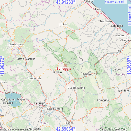
Scheggia GPS coordinates[2]
43° 24' 13.104" North, 12° 39' 57.024" East
| Map corner | latitude | longitude |
|---|---|---|
| Upper-left | 43.91233°, | 11.96272° |
| Center: | 43.40364°, | 12.66584° |
| Lower-right: | 42.89064°, | 13.36897° |
| Map W x H: | 113.6×113.6 km | = 70.6×70.6mi |
| max Lat: | 47.04031° ⇑60.6% North |
| Scheggia: | 43.40364° |
| min Lat: | ⇓39.4% South 35.50142° |
| min Long | Scheggia | max Long |
| 6.69888° | 12.66584° | 18.48682° |
| W 64.5%⇐ | ⇒35.5% E |
Elevation
Elevation of Scheggia is 598 m = 1962 ft, and this is 291.3 m = 956 ft above average elevation for this country.
| Max E: |
2085 m = 6841 ft | 15.6% |
| Scheggia | 598 m 1962 ft | |
| Avg. | 306.7 m = 1006 ft | |
Min E: |
-4 m = -13 ft | 84.4% |
See also: Italy elevation on elevation.city.
Geographical zone
Scheggia is located in North temperate zone (between Tropic of Cancer and the Arctic Circle). Distance of this Northern Tropic circle is 2220.1 km =1379.5 mi to South.| Distance of | km | miles | from Scheggia |
|---|---|---|---|
| North Pole | 5181 | 3219.3 | to North |
| Arctic Circle | 2575.1 | 1600.1 | to North |
| Tropic Cancer | 2220.1 | 1379.5 | to South |
| Equator | 4826 | 2998.7 | to South |


Nearby cities:
15 places around Scheggia: (largest is in red/bold)
• Branca
14.5 km =9 mi,  175°
175°
• Cantiano
8 km =5 mi,  338°
338°
• Casanova di Torre
12.4 km =7.7 mi, 182°
• Cipolleto
11.4 km =7.1 mi,  219°
219°
• Costacciaro
6.3 km =3.9 mi,  142°
142°
• Fossato di Vico
14.2 km =8.8 mi,  147°
147°
• Frontone
13.7 km =8.5 mi,  25°
25°
• Gubbio
9.6 km =6 mi,  231°
231°
• Padule-San Marco
9.5 km =5.9 mi,  208°
208°
• Ponte d'Assi
12.6 km =7.8 mi, 214°
• Purello
12.1 km =7.5 mi, 142°
• Semonte-Casamorcia
11.6 km =7.2 mi,  250°
250°
• Serra Sant'Abbondio
13.1 km =8.1 mi,  41°
41°
• Sigillo
10.1 km =6.3 mi, 143°
• Stazione di Padule
11.4 km =7.1 mi,  200°
200°
Sources, notices
• [Note1] Compared only with cities in Italy existing in our database
• [Src1] Map data: © OpenStreetMap contributors (CC-BY-SA)
• [Src2] Other city data from geonames.org with taken over terms of usage.
• [Src3] Geographical zone / Annual Mean Temperature by Robert A. Rohde @ Wikipedia
