Bruna geodata
Bruna (Umbria) is a populated place; located in Italy in Europe/Rome (GMT+2) time zone. With population of 1,265 people, there are 5739 cities with bigger population in this country. Compared to other cities in Italy, 64.5% of cities are located further ↑North; 64.8% of cities are located further ←West and 50.7% of cities have lower elevation than Bruna. Note1


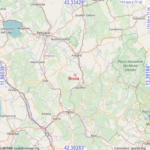
Bruna GPS coordinates[2]
42° 49' 14.556" North, 12° 41' 18.636" East
| Map corner | latitude | longitude |
|---|---|---|
| Upper-left | 43.33429°, | 11.98539° |
| Center: | 42.82071°, | 12.68851° |
| Lower-right: | 42.30283°, | 13.39164° |
| Map W x H: | 114.7×114.7 km | = 71.3×71.3mi |
| max Lat: | 47.04031° ⇑64.5% North |
| Bruna: | 42.82071° |
| min Lat: | ⇓35.5% South 35.50142° |
| min Long | Bruna | max Long |
| 6.69888° | 12.68851° | 18.48682° |
| W 64.8%⇐ | ⇒35.2% E |
Elevation
Elevation of Bruna is 239 m = 784 ft, and this is 67.7 m = 222 ft below average elevation for this country.
| Max E: |
2085 m = 6841 ft | 49.3% |
| Avg. | 306.7 m = 1006 ft | |
| Bruna | 239 m = 784 ft | |
Min E: |
-4 m = -13 ft | 50.7% |
See also: Italy elevation on elevation.city.
Geographical zone
Bruna is located in North temperate zone (between Tropic of Cancer and the Arctic Circle). Distance of this Northern Tropic circle is 2155.3 km =1339.2 mi to South.| Distance of | km | miles | from Bruna |
|---|---|---|---|
| North Pole | 5245.8 | 3259.6 | to North |
| Arctic Circle | 2640 | 1640.4 | to North |
| Tropic Cancer | 2155.3 | 1339.2 | to South |
| Equator | 4761.2 | 2958.5 | to South |


Nearby cities:
15 places around Bruna: (largest is in red/bold)
• Bastardo
11.9 km =7.4 mi,  298°
298°
• Bevagna
14.3 km =8.9 mi,  335°
335°
• Campello sul Clitunno
6.6 km =4.1 mi,  84°
84°
• Cannaiola
5.3 km =3.3 mi,  22°
22°
• Castel Ritaldi
1.2 km =0.7 mi,  279°
279°
• Corciano-Pigge
6 km =3.7 mi,  56°
56°
• Cortaccione
8.5 km =5.3 mi,  137°
137°
• Giano dell'Umbria
9.1 km =5.7 mi, 279°
• Massa Martana
14.3 km =8.9 mi,  248°
248°
• Montefalco
8.5 km =5.3 mi, 337°
• San Giacomo
6 km =3.7 mi,  119°
119°
• San Martino in Trignano
9 km =5.6 mi,  190°
190°
• Santa Maria in Valle
9.5 km =5.9 mi,  31°
31°
• Spoleto
9.8 km =6.1 mi,  155°
155°
• Trevi
8 km =5 mi,  38°
38°
Sources, notices
• [Note1] Compared only with cities in Italy existing in our database
• [Src1] Map data: © OpenStreetMap contributors (CC-BY-SA)
• [Src2] Other city data from geonames.org with taken over terms of usage.
• [Src3] Geographical zone / Annual Mean Temperature by Robert A. Rohde @ Wikipedia
