Sacile geodata
Sacile (Friuli Venezia Giulia) is a seat of a third-order administrative division; located in Italy in Europe/Rome (GMT+2) time zone. With population of 16,626 people, there are 540 cities with bigger population in this country. Compared to other cities in Italy, 90.7% of cities are located further ↓South; 62.4% of cities are located further ←West and 87.4% of cities have higher elevation than Sacile. Note1
Administrative division(s):
- Level 1: Friuli Venezia Giulia
- Level 2: Provincia di Pordenone
- Level 3: Sacile


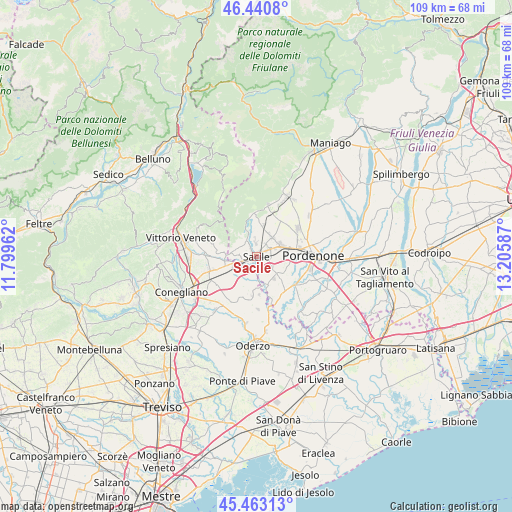
Sacile GPS coordinates[2]
45° 57' 14.832" North, 12° 30' 9.864" East
| Map corner | latitude | longitude |
|---|---|---|
| Upper-left | 46.4408°, | 11.79962° |
| Center: | 45.95412°, | 12.50274° |
| Lower-right: | 45.46313°, | 13.20587° |
| Map W x H: | 108.7×108.7 km | = 67.5×67.5mi |
| max Lat: | 47.04031° ⇑9.3% North |
| Sacile: | 45.95412° |
| min Lat: | ⇓90.7% South 35.50142° |
| min Long | Sacile | max Long |
| 6.69888° | 12.50274° | 18.48682° |
| W 62.4%⇐ | ⇒37.6% E |
Elevation
Elevation of Sacile is 24 m = 79 ft, and this is 282.7 m = 927 ft below average elevation for this country.
| Max E: |
2085 m = 6841 ft | 87.4% |
| Avg. | 306.7 m = 1006 ft | |
| Sacile | 24 m = 79 ft | |
Min E: |
-4 m = -13 ft | 12.6% |
See also: Italy elevation on elevation.city.
Geographical zone
Sacile is located in North temperate zone (between Tropic of Cancer and the Arctic Circle). Distance of this North polar circle is 2291.6 km =1423.9 mi to North.| Distance of | km | miles | from Sacile |
|---|---|---|---|
| North Pole | 4897.4 | 3043.1 | to North |
| Arctic Circle | 2291.6 | 1423.9 | to North |
| Tropic Cancer | 2503.7 | 1555.7 | to South |
| Equator | 5109.6 | 3175 | to South |


Nearby cities:
15 places around Sacile: (largest is in red/bold)
• Albina
8 km =5 mi,  173°
173°
• Bibano
7.5 km =4.7 mi,  226°
226°
• Brugnera
6.8 km =4.2 mi,  153°
153°
• Caneva
4.3 km =2.7 mi,  295°
295°
• Cavolano-Schiavoi
2.3 km =1.4 mi,  185°
185°
• Cordignano
6.8 km =4.2 mi,  265°
265°
• Francenigo
5.1 km =3.2 mi,  179°
179°
• Nave
2.8 km =1.7 mi,  359°
359°
• Orsago
6.4 km =4 mi,  245°
245°
• Palse
8 km =5 mi,  95°
95°
• San Giovanni
7.5 km =4.7 mi,  7°
7°
• San Giovanni di Livenza
3.9 km =2.4 mi, 165°
• Tamai
6.3 km =3.9 mi,  121°
121°
• Vigonovo-Fontanafredda
5.2 km =3.2 mi,  41°
41°
• Villa di Villa
6.9 km =4.3 mi,  281°
281°
Sources, notices
• [Note1] Compared only with cities in Italy existing in our database
• [Src1] Map data: © OpenStreetMap contributors (CC-BY-SA)
• [Src2] Other city data from geonames.org with taken over terms of usage.
• [Src3] Geographical zone / Annual Mean Temperature by Robert A. Rohde @ Wikipedia
