Romola geodata
Romola (Tuscany) is a populated place; located in Italy in Europe/Rome (GMT+2) time zone. With population of 778 people, there are 7773 cities with bigger population in this country. Compared to other cities in Italy, 58.1% of cities are located further ↑North; 54.9% of cities are located further →East and 52.1% of cities have lower elevation than Romola. Note1
Administrative division(s):
- Level 1: Tuscany
- Level 2: Province of Florence
- Level 3: San Casciano in Val di Pesa


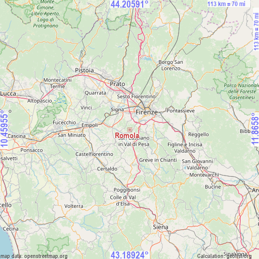
Romola GPS coordinates[2]
43° 41' 59.028" North, 11° 9' 45.612" East
| Map corner | latitude | longitude |
|---|---|---|
| Upper-left | 44.20591°, | 10.45955° |
| Center: | 43.69973°, | 11.16267° |
| Lower-right: | 43.18924°, | 11.8658° |
| Map W x H: | 113×113 km | = 70.2×70.2mi |
| max Lat: | 47.04031° ⇑58.1% North |
| Romola: | 43.69973° |
| min Lat: | ⇓41.9% South 35.50142° |
| min Long | Romola | max Long |
| 6.69888° | 11.16267° | 18.48682° |
| W 45.1%⇐ | ⇒54.9% E |
Elevation
Elevation of Romola is 247 m = 810 ft, and this is 59.7 m = 196 ft below average elevation for this country.
| Max E: |
2085 m = 6841 ft | 47.9% |
| Avg. | 306.7 m = 1006 ft | |
| Romola | 247 m = 810 ft | |
Min E: |
-4 m = -13 ft | 52.1% |
See also: Italy elevation on elevation.city.
Geographical zone
Romola is located in North temperate zone (between Tropic of Cancer and the Arctic Circle). Distance of this Northern Tropic circle is 2253 km =1399.9 mi to South.| Distance of | km | miles | from Romola |
|---|---|---|---|
| North Pole | 5148.1 | 3198.9 | to North |
| Arctic Circle | 2542.2 | 1579.6 | to North |
| Tropic Cancer | 2253 | 1399.9 | to South |
| Equator | 4859 | 3019.2 | to South |


Nearby cities:
15 places around Romola: (largest is in red/bold)
• Baccaiano
7.5 km =4.7 mi,  239°
239°
• Cerbaia
3.2 km =2 mi, 239°
• Chiesanuova
2 km =1.2 mi,  74°
74°
• Ginestra Fiorentina
7.2 km =4.5 mi,  278°
278°
• Impruneta
7.6 km =4.7 mi,  102°
102°
• Lastra a Signa
8.8 km =5.5 mi,  332°
332°
• Malmantile
8.9 km =5.5 mi,  306°
306°
• Mercatale
8.7 km =5.4 mi,  143°
143°
• Quattro Strade
8.1 km =5 mi, 305°
• San Casciano in Val di Pesa
4.8 km =3 mi,  158°
158°
• San Martino alla Palma
5.7 km =3.5 mi,  344°
344°
• San Quirico in Collina
6.2 km =3.9 mi,  207°
207°
• San Vincenzo a Torri
5.3 km =3.3 mi,  271°
271°
• Scandicci
6.4 km =4 mi,  18°
18°
• Tavarnuzze
4.5 km =2.8 mi,  75°
75°
Sources, notices
• [Note1] Compared only with cities in Italy existing in our database
• [Src1] Map data: © OpenStreetMap contributors (CC-BY-SA)
• [Src2] Other city data from geonames.org with taken over terms of usage.
• [Src3] Geographical zone / Annual Mean Temperature by Robert A. Rohde @ Wikipedia
