San Martino alla Palma geodata
San Martino alla Palma (Tuscany) is a populated place; located in Italy in Europe/Rome (GMT+2) time zone. With population of 634 people, there are 8749 cities with bigger population in this country. Compared to other cities in Italy, 57.5% of cities are located further ↑North; 55.2% of cities are located further →East and 61.2% of cities have higher elevation than San Martino alla Palma. Note1
Current local time in San Martino alla Palma:
09:40 PM, WednesdayDifference from your time zone: hours


San Martino alla Palma GPS coordinates[2]
43° 44' 57.156" North, 11° 8' 37.176" East
| Map corner | latitude | longitude |
|---|---|---|
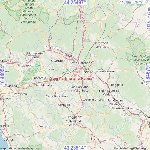
| Upper-left | 44.25497°, | 10.44054° |
| Center: | 43.74921°, | 11.14366° |
| Lower-right: | 43.23914°, | 11.84679° |
| Map W x H: | 112.9×112.9 km | = 70.2×70.2mi |
| max Lat: | 47.04031° ⇑57.5% North |
| San Martino alla Palma: | 43.74921° |
| min Lat: | ⇓42.5% South 35.50142° |
| min Long | San Martino all | max Long |
| 6.69888° | 11.14366° | 18.48682° |
| W 44.8%⇐ | ⇒55.2% E |
Elevation
Elevation of San Martino alla Palma is 154 m = 505 ft, and this is 152.7 m = 501 ft below average elevation for this country.
| Max E: |
2085 m = 6841 ft | 61.2% |
| Avg. | 306.7 m = 1006 ft | |
| San Martino alla Palma | 154 m = 505 ft | |
Min E: |
-4 m = -13 ft | 38.8% |
See also: Italy elevation on elevation.city.
Geographical zone
San Martino alla Palma is located in North temperate zone (between Tropic of Cancer and the Arctic Circle). Distance of this Northern Tropic circle is 2258.5 km =1403.4 mi to South.| Distance of | km | miles | from San Martino alla Palma |
|---|---|---|---|
| North Pole | 5142.6 | 3195.5 | to North |
| Arctic Circle | 2536.7 | 1576.2 | to North |
| Tropic Cancer | 2258.5 | 1403.4 | to South |
| Equator | 4864.5 | 3022.7 | to South |


Nearby cities:
15 places around San Martino alla Palma: (largest is in red/bold)
• Cerbaia
7.2 km =4.5 mi,  189°
189°
• Chiesanuova
6 km =3.7 mi,  145°
145°
• Comeana
8.4 km =5.2 mi,  305°
305°
• Ginestra Fiorentina
7.1 km =4.4 mi,  231°
231°
• Lastra a Signa
3.4 km =2.1 mi, 312°
• Malmantile
5.7 km =3.5 mi,  267°
267°
• Mantignano-Ugnano
4.2 km =2.6 mi,  29°
29°
• Quattro Strade
5.1 km =3.2 mi,  260°
260°
• Romola
5.7 km =3.5 mi,  164°
164°
• San Donnino
5.1 km =3.2 mi,  2°
2°
• San Mauro
5.2 km =3.2 mi,  343°
343°
• San Vincenzo a Torri
6.6 km =4.1 mi,  215°
215°
• Scandicci
3.6 km =2.2 mi,  81°
81°
• Signa
5.9 km =3.7 mi,  327°
327°
• Tavarnuzze
7.3 km =4.5 mi,  126°
126°
Sources, notices
• [Note1] Compared only with cities in Italy existing in our database
• [Src1] Map data: © OpenStreetMap contributors (CC-BY-SA)
• [Src2] Other city data from geonames.org with taken over terms of usage.
• [Src3] Geographical zone / Annual Mean Temperature by Robert A. Rohde @ Wikipedia
