Scandicci geodata
Scandicci (Tuscany) is a seat of a third-order administrative division; located in Italy in Europe/Rome (GMT+2) time zone. With population of 44,951 people, there are 154 cities with bigger population in this country. Compared to other cities in Italy, 57.5% of cities are located further ↑North; 54.5% of cities are located further →East and 80.9% of cities have higher elevation than Scandicci. Note1


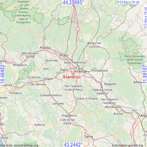
Scandicci GPS coordinates[2]
43° 45' 15.228" North, 11° 11' 16.584" East
| Map corner | latitude | longitude |
|---|---|---|
| Upper-left | 44.25995°, | 10.48482° |
| Center: | 43.75423°, | 11.18794° |
| Lower-right: | 43.2442°, | 11.89107° |
| Map W x H: | 112.9×112.9 km | = 70.2×70.2mi |
| max Lat: | 47.04031° ⇑57.5% North |
| Scandicci: | 43.75423° |
| min Lat: | ⇓42.5% South 35.50142° |
| min Long | Scandicci | max Long |
| 6.69888° | 11.18794° | 18.48682° |
| W 45.5%⇐ | ⇒54.5% E |
Elevation
Elevation of Scandicci is 46 m = 151 ft, and this is 260.7 m = 855 ft below average elevation for this country.
| Max E: |
2085 m = 6841 ft | 80.9% |
| Avg. | 306.7 m = 1006 ft | |
| Scandicci | 46 m = 151 ft | |
Min E: |
-4 m = -13 ft | 19.1% |
See also: Scandicci elevation on elevation.city.
Geographical zone
Scandicci is located in North temperate zone (between Tropic of Cancer and the Arctic Circle). Distance of this Northern Tropic circle is 2259.1 km =1403.7 mi to South.| Distance of | km | miles | from Scandicci |
|---|---|---|---|
| North Pole | 5142 | 3195.1 | to North |
| Arctic Circle | 2536.2 | 1575.9 | to North |
| Tropic Cancer | 2259.1 | 1403.7 | to South |
| Equator | 4865 | 3023 | to South |


Nearby cities:
15 places around Scandicci: (largest is in red/bold)
• Campi Bisenzio
9.1 km =5.7 mi,  329°
329°
• Cerbaia
9 km =5.6 mi,  211°
211°
• Chiesanuova
5.5 km =3.4 mi,  181°
181°
• Florence
5.4 km =3.4 mi,  59°
59°
• Grassina Ponte a Ema
9.3 km =5.8 mi,  104°
104°
• Lastra a Signa
6.3 km =3.9 mi,  286°
286°
• Mantignano-Ugnano
3.4 km =2.1 mi, 334°
• Quattro Strade
8.7 km =5.4 mi,  260°
260°
• Romola
6.4 km =4 mi,  198°
198°
• San Donnino
5.7 km =3.5 mi,  324°
324°
• San Martino alla Palma
3.6 km =2.2 mi, 261°
• San Mauro
6.7 km =4.2 mi,  311°
311°
• Sesto Fiorentino
8.7 km =5.4 mi,  5°
5°
• Signa
8.1 km =5 mi,  303°
303°
• Tavarnuzze
5.4 km =3.4 mi,  154°
154°
Sources, notices
• [Note1] Compared only with cities in Italy existing in our database
• [Src1] Map data: © OpenStreetMap contributors (CC-BY-SA)
• [Src2] Other city data from geonames.org with taken over terms of usage.
• [Src3] Geographical zone / Annual Mean Temperature by Robert A. Rohde @ Wikipedia
