Chiesanuova geodata
Chiesanuova (Tuscany) is a populated place; located in Italy in Europe/Rome (GMT+2) time zone. With population of 717 people, there are 8174 cities with bigger population in this country. Compared to other cities in Italy, 58.1% of cities are located further ↑North; 54.6% of cities are located further →East and 50.2% of cities have higher elevation than Chiesanuova. Note1
Administrative division(s):
- Level 1: Tuscany
- Level 2: Province of Florence
- Level 3: San Casciano in Val di Pesa


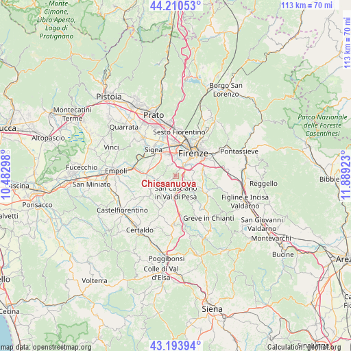
Chiesanuova GPS coordinates[2]
43° 42' 15.804" North, 11° 11' 9.96" East
| Map corner | latitude | longitude |
|---|---|---|
| Upper-left | 44.21053°, | 10.48298° |
| Center: | 43.70439°, | 11.1861° |
| Lower-right: | 43.19394°, | 11.88923° |
| Map W x H: | 113×113 km | = 70.2×70.2mi |
| max Lat: | 47.04031° ⇑58.1% North |
| Chiesanuova: | 43.70439° |
| min Lat: | ⇓41.9% South 35.50142° |
| min Long | Chiesanuova | max Long |
| 6.69888° | 11.1861° | 18.48682° |
| W 45.4%⇐ | ⇒54.6% E |
Elevation
Elevation of Chiesanuova is 234 m = 768 ft, and this is 72.7 m = 239 ft below average elevation for this country.
| Max E: |
2085 m = 6841 ft | 50.2% |
| Avg. | 306.7 m = 1006 ft | |
| Chiesanuova | 234 m = 768 ft | |
Min E: |
-4 m = -13 ft | 49.8% |
See also: Italy elevation on elevation.city.
Geographical zone
Chiesanuova is located in North temperate zone (between Tropic of Cancer and the Arctic Circle). Distance of this Northern Tropic circle is 2253.6 km =1400.3 mi to South.| Distance of | km | miles | from Chiesanuova |
|---|---|---|---|
| North Pole | 5147.6 | 3198.6 | to North |
| Arctic Circle | 2541.7 | 1579.3 | to North |
| Tropic Cancer | 2253.6 | 1400.3 | to South |
| Equator | 4859.5 | 3019.6 | to South |


Nearby cities:
15 places around Chiesanuova: (largest is in red/bold)
• Baccaiano
9.4 km =5.8 mi,  242°
242°
• Cerbaia
5.1 km =3.2 mi,  245°
245°
• Ginestra Fiorentina
9 km =5.6 mi,  273°
273°
• Impruneta
5.9 km =3.7 mi,  111°
111°
• Lastra a Signa
9.4 km =5.8 mi,  321°
321°
• Mantignano-Ugnano
8.7 km =5.4 mi,  351°
351°
• Mercatale
8.2 km =5.1 mi,  155°
155°
• Quattro Strade
9.4 km =5.8 mi,  295°
295°
• Romola
2 km =1.2 mi, 254°
• San Casciano in Val di Pesa
5 km =3.1 mi,  181°
181°
• San Martino alla Palma
6 km =3.7 mi,  325°
325°
• San Quirico in Collina
7.7 km =4.8 mi,  218°
218°
• San Vincenzo a Torri
7.2 km =4.5 mi, 266°
• Scandicci
5.5 km =3.4 mi,  1°
1°
• Tavarnuzze
2.6 km =1.6 mi,  75°
75°
Sources, notices
• [Note1] Compared only with cities in Italy existing in our database
• [Src1] Map data: © OpenStreetMap contributors (CC-BY-SA)
• [Src2] Other city data from geonames.org with taken over terms of usage.
• [Src3] Geographical zone / Annual Mean Temperature by Robert A. Rohde @ Wikipedia
