Reggiolo geodata
Reggiolo (Emilia-Romagna) is a seat of a third-order administrative division; located in Italy in Europe/Rome (GMT+2) time zone. With population of 6,753 people, there are 1456 cities with bigger population in this country. Compared to other cities in Italy, 58.3% of cities are located further ↓South; 59.6% of cities are located further →East and 88.7% of cities have higher elevation than Reggiolo. Note1
Administrative division(s):
- Level 1: Emilia-Romagna
- Level 2: Provincia di Reggio Emilia
- Level 3: Reggiolo


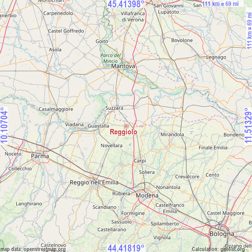
Reggiolo GPS coordinates[2]
44° 55' 5.664" North, 10° 48' 36.576" East
| Map corner | latitude | longitude |
|---|---|---|
| Upper-left | 45.41398°, | 10.10704° |
| Center: | 44.91824°, | 10.81016° |
| Lower-right: | 44.41819°, | 11.51329° |
| Map W x H: | 110.7×110.7 km | = 68.8×68.8mi |
| max Lat: | 47.04031° ⇑41.7% North |
| Reggiolo: | 44.91824° |
| min Lat: | ⇓58.3% South 35.50142° |
| min Long | Reggiolo | max Long |
| 6.69888° | 10.81016° | 18.48682° |
| W 40.4%⇐ | ⇒59.6% E |
Elevation
Elevation of Reggiolo is 21 m = 69 ft, and this is 285.7 m = 937 ft below average elevation for this country.
| Max E: |
2085 m = 6841 ft | 88.7% |
| Avg. | 306.7 m = 1006 ft | |
| Reggiolo | 21 m = 69 ft | |
Min E: |
-4 m = -13 ft | 11.3% |
See also: Italy elevation on elevation.city.
Geographical zone
Reggiolo is located in North temperate zone (between Tropic of Cancer and the Arctic Circle). Distance of this Northern Tropic circle is 2388.5 km =1484.1 mi to South.| Distance of | km | miles | from Reggiolo |
|---|---|---|---|
| North Pole | 5012.6 | 3114.7 | to North |
| Arctic Circle | 2406.7 | 1495.5 | to North |
| Tropic Cancer | 2388.5 | 1484.1 | to South |
| Equator | 4994.4 | 3103.4 | to South |


Nearby cities:
15 places around Reggiolo: (largest is in red/bold)
• Bondeno
4.4 km =2.7 mi,  63°
63°
• Brugneto
3.8 km =2.4 mi,  276°
276°
• Campagnola Emilia
9.5 km =5.9 mi,  202°
202°
• Codisotto
9.7 km =6 mi,  317°
317°
• Fabbrico
5.1 km =3.2 mi,  181°
181°
• Gonzaga
3.8 km =2.4 mi,  10°
10°
• Moglia
8.4 km =5.2 mi,  76°
76°
• Novellara
10.4 km =6.5 mi,  218°
218°
• Novi di Modena
7.8 km =4.8 mi,  114°
114°
• Palidano
6.5 km =4 mi,  337°
337°
• Pegognaga
9.3 km =5.8 mi,  24°
24°
• Polesine
7.5 km =4.7 mi,  356°
356°
• Rolo
5.4 km =3.4 mi,  133°
133°
• Suzzara
9.8 km =6.1 mi,  327°
327°
• Villarotta
5.3 km =3.3 mi, 278°
Sources, notices
• [Note1] Compared only with cities in Italy existing in our database
• [Src1] Map data: © OpenStreetMap contributors (CC-BY-SA)
• [Src2] Other city data from geonames.org with taken over terms of usage.
• [Src3] Geographical zone / Annual Mean Temperature by Robert A. Rohde @ Wikipedia
