Premilcuore geodata
Premilcuore (Emilia-Romagna) is a seat of a third-order administrative division; located in Italy in Europe/Rome (GMT+2) time zone. With population of 613 people, there are 8895 cities with bigger population in this country. Compared to other cities in Italy, 54.9% of cities are located further ↑North; 52.8% of cities are located further ←West and 76.7% of cities have lower elevation than Premilcuore. Note1
Administrative division(s):
- Level 1: Emilia-Romagna
- Level 2: Provincia di Forlì-Cesena
- Level 3: Premilcuore


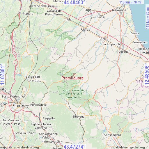
Premilcuore GPS coordinates[2]
43° 58' 51.024" North, 11° 46' 54.948" East
| Map corner | latitude | longitude |
|---|---|---|
| Upper-left | 44.48463°, | 11.07881° |
| Center: | 43.98084°, | 11.78193° |
| Lower-right: | 43.47274°, | 12.48506° |
| Map W x H: | 112.5×112.5 km | = 69.9×69.9mi |
| max Lat: | 47.04031° ⇑54.9% North |
| Premilcuore: | 43.98084° |
| min Lat: | ⇓45.1% South 35.50142° |
| min Long | Premilcuore | max Long |
| 6.69888° | 11.78193° | 18.48682° |
| W 52.8%⇐ | ⇒47.2% E |
Elevation
Elevation of Premilcuore is 476 m = 1562 ft, and this is 169.3 m = 555 ft above average elevation for this country.
| Max E: |
2085 m = 6841 ft | 23.3% |
| Premilcuore | 476 m 1562 ft | |
| Avg. | 306.7 m = 1006 ft | |
Min E: |
-4 m = -13 ft | 76.7% |
See also: Italy elevation on elevation.city.
Geographical zone
Premilcuore is located in North temperate zone (between Tropic of Cancer and the Arctic Circle). Distance of this Northern Tropic circle is 2284.3 km =1419.4 mi to South.| Distance of | km | miles | from Premilcuore |
|---|---|---|---|
| North Pole | 5116.9 | 3179.5 | to North |
| Arctic Circle | 2511 | 1560.3 | to North |
| Tropic Cancer | 2284.3 | 1419.4 | to South |
| Equator | 4890.2 | 3038.6 | to South |


Nearby cities:
15 places around Premilcuore: (largest is in red/bold)
• Civitella di Romagna
13.3 km =8.3 mi,  76°
76°
• Cusercoli
19.4 km =12.1 mi,  68°
68°
• Dovadola
17.8 km =11.1 mi,  28°
28°
• Galeata
10.4 km =6.5 mi, 80°
• Marradi
17.1 km =10.6 mi,  307°
307°
• Modigliana
19.9 km =12.4 mi,  2°
2°
• Portico di Romagna
5.1 km =3.2 mi,  359°
359°
• Portico e San Benedetto
5.1 km =3.2 mi, 359°
• Predappio
21.1 km =13.1 mi,  49°
49°
• Rocca San Casciano
9.9 km =6.2 mi, 29°
• San Godenzo
14.4 km =8.9 mi,  244°
244°
• San Piero in Bagno
20.8 km =12.9 mi,  131°
131°
• Santa Sofia
10.8 km =6.7 mi,  110°
110°
• Stia
21.1 km =13.1 mi,  196°
196°
• Tredozio
11.4 km =7.1 mi,  343°
343°
Sources, notices
• [Note1] Compared only with cities in Italy existing in our database
• [Src1] Map data: © OpenStreetMap contributors (CC-BY-SA)
• [Src2] Other city data from geonames.org with taken over terms of usage.
• [Src3] Geographical zone / Annual Mean Temperature by Robert A. Rohde @ Wikipedia
