Portovenere geodata
Portovenere (Liguria) is a seat of a third-order administrative division; located in Italy in Europe/Rome (GMT+2) time zone. With population of 1,025 people, there are 6565 cities with bigger population in this country. Compared to other cities in Italy, 54.2% of cities are located further ↑North; 69.5% of cities are located further →East and 90.1% of cities have higher elevation than Portovenere. Note1


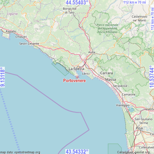
Portovenere GPS coordinates[2]
44° 3' 2.988" North, 9° 50' 3.516" East
| Map corner | latitude | longitude |
|---|---|---|
| Upper-left | 44.55403°, | 9.13118° |
| Center: | 44.05083°, | 9.83431° |
| Lower-right: | 43.54332°, | 10.53744° |
| Map W x H: | 112.4×112.4 km | = 69.8×69.8mi |
| max Lat: | 47.04031° ⇑54.2% North |
| Portovenere: | 44.05083° |
| min Lat: | ⇓45.8% South 35.50142° |
| min Long | Portovenere | max Long |
| 6.69888° | 9.83431° | 18.48682° |
| W 30.5%⇐ | ⇒69.5% E |
Elevation
Elevation of Portovenere is 18 m = 59 ft, and this is 288.7 m = 947 ft below average elevation for this country.
| Max E: |
2085 m = 6841 ft | 90.1% |
| Avg. | 306.7 m = 1006 ft | |
| Portovenere | 18 m = 59 ft | |
Min E: |
-4 m = -13 ft | 9.9% |
See also: Italy elevation on elevation.city.
Geographical zone
Portovenere is located in North temperate zone (between Tropic of Cancer and the Arctic Circle). Distance of this Northern Tropic circle is 2292.1 km =1424.2 mi to South.| Distance of | km | miles | from Portovenere |
|---|---|---|---|
| North Pole | 5109.1 | 3174.6 | to North |
| Arctic Circle | 2503.2 | 1555.4 | to North |
| Tropic Cancer | 2292.1 | 1424.2 | to South |
| Equator | 4898 | 3043.5 | to South |


Nearby cities:
15 places around Portovenere: (largest is in red/bold)
• Ameglia
10.8 km =6.7 mi,  78°
78°
• Arcola
9.7 km =6 mi,  39°
39°
• Fezzano
3.4 km =2.1 mi,  348°
348°
• La Spezia
5.9 km =3.7 mi, 351°
• Le Grazie
1.8 km =1.1 mi,  359°
359°
• Lerici
6.7 km =4.2 mi,  65°
65°
• Piano di Valeriano-Bottagna
11.6 km =7.2 mi,  15°
15°
• Pitelli
6.3 km =3.9 mi, 39°
• Riomaggiore
9.4 km =5.8 mi,  305°
305°
• Romito Magra
9.4 km =5.8 mi,  55°
55°
• San Benedetto
10.3 km =6.4 mi,  333°
333°
• San Terenzo
6.3 km =3.9 mi,  52°
52°
• Stazione-Fornola
9.9 km =6.2 mi,  27°
27°
• Tellaro
7.6 km =4.7 mi, 80°
• Vezzano Ligure
10.9 km =6.8 mi, 22°
Sources, notices
• [Note1] Compared only with cities in Italy existing in our database
• [Src1] Map data: © OpenStreetMap contributors (CC-BY-SA)
• [Src2] Other city data from geonames.org with taken over terms of usage.
• [Src3] Geographical zone / Annual Mean Temperature by Robert A. Rohde @ Wikipedia
