Umbertide geodata
Umbertide (Umbria) is a seat of a third-order administrative division; located in Italy in Europe/Rome (GMT+2) time zone. With population of 11,040 people, there are 855 cities with bigger population in this country. Compared to other cities in Italy, 61.1% of cities are located further ↑North; 60.5% of cities are located further ←West and 51.9% of cities have lower elevation than Umbertide. Note1


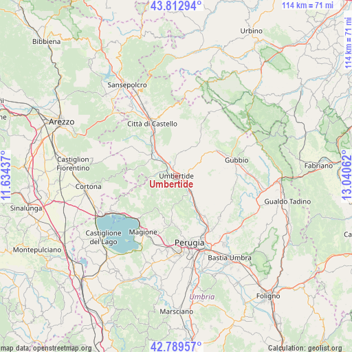
Umbertide GPS coordinates[2]
43° 18' 12.276" North, 12° 20' 14.964" East
| Map corner | latitude | longitude |
|---|---|---|
| Upper-left | 43.81294°, | 11.63437° |
| Center: | 43.30341°, | 12.33749° |
| Lower-right: | 42.78957°, | 13.04062° |
| Map W x H: | 113.8×113.8 km | = 70.7×70.7mi |
| max Lat: | 47.04031° ⇑61.1% North |
| Umbertide: | 43.30341° |
| min Lat: | ⇓38.9% South 35.50142° |
| min Long | Umbertide | max Long |
| 6.69888° | 12.33749° | 18.48682° |
| W 60.5%⇐ | ⇒39.5% E |
Elevation
Elevation of Umbertide is 246 m = 807 ft, and this is 60.7 m = 199 ft below average elevation for this country.
| Max E: |
2085 m = 6841 ft | 48.1% |
| Avg. | 306.7 m = 1006 ft | |
| Umbertide | 246 m = 807 ft | |
Min E: |
-4 m = -13 ft | 51.9% |
See also: Italy elevation on elevation.city.
Geographical zone
Umbertide is located in North temperate zone (between Tropic of Cancer and the Arctic Circle). Distance of this Northern Tropic circle is 2209 km =1372.6 mi to South.| Distance of | km | miles | from Umbertide |
|---|---|---|---|
| North Pole | 5192.2 | 3226.3 | to North |
| Arctic Circle | 2586.3 | 1607.1 | to North |
| Tropic Cancer | 2209 | 1372.6 | to South |
| Equator | 4814.9 | 2991.8 | to South |


Nearby cities:
15 places around Umbertide: (largest is in red/bold)
• Casa del Diavolo
15.7 km =9.8 mi,  144°
144°
• Comparati
16 km =9.9 mi,  183°
183°
• La Cinella
7 km =4.3 mi, 135°
• Mantignana
16.4 km =10.2 mi,  193°
193°
• Montone
6.5 km =4 mi,  349°
349°
• Oscano
16.1 km =10 mi, 179°
• Pierantonio
6 km =3.7 mi, 136°
• Pietralunga
16.5 km =10.3 mi,  26°
26°
• Ponte Pattoli
15.8 km =9.8 mi,  152°
152°
• Promano
9.1 km =5.7 mi,  321°
321°
• Resina I
13.3 km =8.3 mi, 147°
• San Secondo
14 km =8.7 mi, 323°
• Stazione di Parlesca e Solfagnano
11.2 km =7 mi, 146°
• Trestina
10.7 km =6.6 mi,  310°
310°
• Verna
9.8 km =6.1 mi, 305°
Sources, notices
• [Note1] Compared only with cities in Italy existing in our database
• [Src1] Map data: © OpenStreetMap contributors (CC-BY-SA)
• [Src2] Other city data from geonames.org with taken over terms of usage.
• [Src3] Geographical zone / Annual Mean Temperature by Robert A. Rohde @ Wikipedia
