Gubbio geodata
Gubbio (Umbria) is a seat of a third-order administrative division; located in Italy in Europe/Rome (GMT+2) time zone. With population of 14,378 people, there are 631 cities with bigger population in this country. Compared to other cities in Italy, 60.8% of cities are located further ↑North; 63.2% of cities are located further ←West and 77.6% of cities have lower elevation than Gubbio. Note1


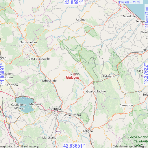
Gubbio GPS coordinates[2]
43° 20' 59.856" North, 12° 34' 23.124" East
| Map corner | latitude | longitude |
|---|---|---|
| Upper-left | 43.8591°, | 11.86997° |
| Center: | 43.34996°, | 12.57309° |
| Lower-right: | 42.83651°, | 13.27622° |
| Map W x H: | 113.7×113.7 km | = 70.6×70.6mi |
| max Lat: | 47.04031° ⇑60.8% North |
| Gubbio: | 43.34996° |
| min Lat: | ⇓39.2% South 35.50142° |
| min Long | Gubbio | max Long |
| 6.69888° | 12.57309° | 18.48682° |
| W 63.2%⇐ | ⇒36.8% E |
Elevation
Elevation of Gubbio is 487 m = 1598 ft, and this is 180.3 m = 592 ft above average elevation for this country.
| Max E: |
2085 m = 6841 ft | 22.4% |
| Gubbio | 487 m 1598 ft | |
| Avg. | 306.7 m = 1006 ft | |
Min E: |
-4 m = -13 ft | 77.6% |
See also: Italy elevation on elevation.city.
Geographical zone
Gubbio is located in North temperate zone (between Tropic of Cancer and the Arctic Circle). Distance of this Northern Tropic circle is 2214.1 km =1375.8 mi to South.| Distance of | km | miles | from Gubbio |
|---|---|---|---|
| North Pole | 5187 | 3223.1 | to North |
| Arctic Circle | 2581.1 | 1603.8 | to North |
| Tropic Cancer | 2214.1 | 1375.8 | to South |
| Equator | 4820.1 | 2995.1 | to South |


Nearby cities:
15 places around Gubbio: (largest is in red/bold)
• Branca
12.2 km =7.6 mi,  134°
134°
• Cantiano
14.2 km =8.8 mi,  18°
18°
• Casanova di Torre
9.5 km =5.9 mi, 132°
• Cipolleto
2.9 km =1.8 mi,  173°
173°
• Costacciaro
11.3 km =7 mi,  85°
85°
• Monte Grimano
15.6 km =9.7 mi,  326°
326°
• Osteria del Gatto
15.7 km =9.8 mi,  117°
117°
• Padule-San Marco
3.8 km =2.4 mi, 128°
• Pietralunga
15.1 km =9.4 mi,  309°
309°
• Ponte d'Assi
4.4 km =2.7 mi,  176°
176°
• Purello
15.3 km =9.5 mi,  103°
103°
• Scheggia
9.6 km =6 mi,  51°
51°
• Semonte-Casamorcia
4 km =2.5 mi,  300°
300°
• Sigillo
13.7 km =8.5 mi, 98°
• Stazione di Padule
5.8 km =3.6 mi,  143°
143°
Sources, notices
• [Note1] Compared only with cities in Italy existing in our database
• [Src1] Map data: © OpenStreetMap contributors (CC-BY-SA)
• [Src2] Other city data from geonames.org with taken over terms of usage.
• [Src3] Geographical zone / Annual Mean Temperature by Robert A. Rohde @ Wikipedia
