Orvieto geodata
Orvieto (Umbria) is a seat of a third-order administrative division; located in Italy in Europe/Rome (GMT+2) time zone. With population of 5,440 people, there are 1802 cities with bigger population in this country. Compared to other cities in Italy, 65.1% of cities are located further ↑North; 57.5% of cities are located further ←West and 62% of cities have lower elevation than Orvieto. Note1


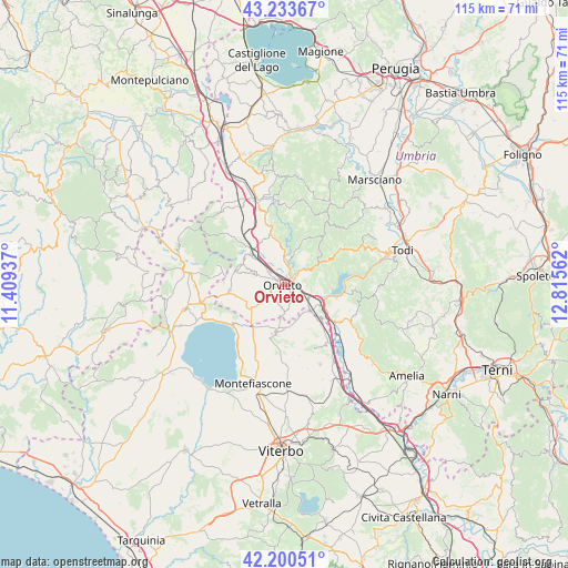
Orvieto GPS coordinates[2]
42° 43' 9.264" North, 12° 6' 44.964" East
| Map corner | latitude | longitude |
|---|---|---|
| Upper-left | 43.23367°, | 11.40937° |
| Center: | 42.71924°, | 12.11249° |
| Lower-right: | 42.20051°, | 12.81562° |
| Map W x H: | 114.9×114.9 km | = 71.4×71.4mi |
| max Lat: | 47.04031° ⇑65.1% North |
| Orvieto: | 42.71924° |
| min Lat: | ⇓34.9% South 35.50142° |
| min Long | Orvieto | max Long |
| 6.69888° | 12.11249° | 18.48682° |
| W 57.5%⇐ | ⇒42.5% E |
Elevation
Elevation of Orvieto is 315 m = 1033 ft, and this is 8.3 m = 27 ft above average elevation for this country.
| Max E: |
2085 m = 6841 ft | 38% |
| Orvieto | 315 m 1033 ft | |
| Avg. | 306.7 m = 1006 ft | |
Min E: |
-4 m = -13 ft | 62% |
See also: Italy elevation on elevation.city.
Geographical zone
Orvieto is located in North temperate zone (between Tropic of Cancer and the Arctic Circle). Distance of this Northern Tropic circle is 2144 km =1332.2 mi to South.| Distance of | km | miles | from Orvieto |
|---|---|---|---|
| North Pole | 5257.1 | 3266.6 | to North |
| Arctic Circle | 2651.2 | 1647.4 | to North |
| Tropic Cancer | 2144 | 1332.2 | to South |
| Equator | 4749.9 | 2951.5 | to South |


Nearby cities:
15 places around Orvieto: (largest is in red/bold)
• Bagnoregio
10.3 km =6.4 mi,  190°
190°
• Baschi
10 km =6.2 mi,  120°
120°
• Canale Nuovo
3.9 km =2.4 mi,  155°
155°
• Castel Giorgio
11.1 km =6.9 mi,  262°
262°
• Castel Viscardo
9.9 km =6.2 mi,  292°
292°
• Castiglione in Teverina
10.6 km =6.6 mi,  135°
135°
• Ciconia
2.4 km =1.5 mi,  47°
47°
• Ficulle
13 km =8.1 mi,  343°
343°
• Lubriano
9.2 km =5.7 mi,  181°
181°
• Monterubiaglio
9.4 km =5.8 mi,  303°
303°
• Orvieto Scalo
1.8 km =1.1 mi,  84°
84°
• Pianlungo
9.4 km =5.8 mi,  317°
317°
• Porano
4.3 km =2.7 mi, 190°
• Sferracavallo
1.6 km =1 mi, 299°
• Stazione di Allerona
9.6 km =6 mi, 320°
Sources, notices
• [Note1] Compared only with cities in Italy existing in our database
• [Src1] Map data: © OpenStreetMap contributors (CC-BY-SA)
• [Src2] Other city data from geonames.org with taken over terms of usage.
• [Src3] Geographical zone / Annual Mean Temperature by Robert A. Rohde @ Wikipedia
