Castel Viscardo geodata
Castel Viscardo (Umbria) is a seat of a third-order administrative division; located in Italy in Europe/Rome (GMT+2) time zone. With population of 1,085 people, there are 6350 cities with bigger population in this country. Compared to other cities in Italy, 64.9% of cities are located further ↑North; 55.9% of cities are located further ←West and 78.1% of cities have lower elevation than Castel Viscardo. Note1


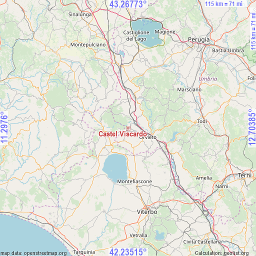
Castel Viscardo GPS coordinates[2]
42° 45' 12.924" North, 12° 0' 2.592" East
| Map corner | latitude | longitude |
|---|---|---|
| Upper-left | 43.26773°, | 11.2976° |
| Center: | 42.75359°, | 12.00072° |
| Lower-right: | 42.23515°, | 12.70385° |
| Map W x H: | 114.8×114.8 km | = 71.3×71.3mi |
| max Lat: | 47.04031° ⇑64.9% North |
| Castel Viscardo: | 42.75359° |
| min Lat: | ⇓35.1% South 35.50142° |
| min Long | Castel Viscardo | max Long |
| 6.69888° | 12.00072° | 18.48682° |
| W 55.9%⇐ | ⇒44.1% E |
Elevation
Elevation of Castel Viscardo is 494 m = 1621 ft, and this is 187.3 m = 615 ft above average elevation for this country.
| Max E: |
2085 m = 6841 ft | 21.9% |
| Castel Viscardo | 494 m 1621 ft | |
| Avg. | 306.7 m = 1006 ft | |
Min E: |
-4 m = -13 ft | 78.1% |
See also: Italy elevation on elevation.city.
Geographical zone
Castel Viscardo is located in North temperate zone (between Tropic of Cancer and the Arctic Circle). Distance of this Northern Tropic circle is 2147.8 km =1334.6 mi to South.| Distance of | km | miles | from Castel Viscardo |
|---|---|---|---|
| North Pole | 5253.3 | 3264.2 | to North |
| Arctic Circle | 2647.4 | 1645 | to North |
| Tropic Cancer | 2147.8 | 1334.6 | to South |
| Equator | 4753.8 | 2953.9 | to South |


Nearby cities:
15 places around Castel Viscardo: (largest is in red/bold)
• Acquapendente
10.9 km =6.8 mi,  263°
263°
• Allerona
6.8 km =4.2 mi,  341°
341°
• Bolsena
12.3 km =7.6 mi,  185°
185°
• Canale Nuovo
13 km =8.1 mi,  124°
124°
• Castel Giorgio
5.5 km =3.4 mi,  200°
200°
• Ciconia
11.1 km =6.9 mi,  101°
101°
• Ficulle
10.3 km =6.4 mi,  32°
32°
• Monterubiaglio
2 km =1.2 mi,  41°
41°
• Orvieto
9.9 km =6.2 mi,  112°
112°
• Orvieto Scalo
11.5 km =7.1 mi, 108°
• Pianlungo
4.2 km =2.6 mi, 42°
• Porano
11.6 km =7.2 mi,  133°
133°
• San Lorenzo Nuovo
10.7 km =6.6 mi,  225°
225°
• Sferracavallo
8.3 km =5.2 mi, 111°
• Stazione di Allerona
4.6 km =2.9 mi, 40°
Sources, notices
• [Note1] Compared only with cities in Italy existing in our database
• [Src1] Map data: © OpenStreetMap contributors (CC-BY-SA)
• [Src2] Other city data from geonames.org with taken over terms of usage.
• [Src3] Geographical zone / Annual Mean Temperature by Robert A. Rohde @ Wikipedia
