Occhiobello geodata
Occhiobello (Veneto) is a seat of a third-order administrative division; located in Italy in Europe/Rome (GMT+2) time zone. With population of 1,991 people, there are 4173 cities with bigger population in this country. Compared to other cities in Italy, 58.4% of cities are located further ↓South; 50.4% of cities are located further ←West and 95.9% of cities have higher elevation than Occhiobello. Note1


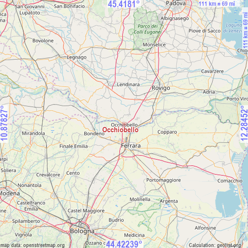
Occhiobello GPS coordinates[2]
44° 55' 20.64" North, 11° 34' 53.004" East
| Map corner | latitude | longitude |
|---|---|---|
| Upper-left | 45.4181°, | 10.87827° |
| Center: | 44.9224°, | 11.58139° |
| Lower-right: | 44.42239°, | 12.28452° |
| Map W x H: | 110.7×110.7 km | = 68.8×68.8mi |
| max Lat: | 47.04031° ⇑41.6% North |
| Occhiobello: | 44.9224° |
| min Lat: | ⇓58.4% South 35.50142° |
| min Long | Occhiobello | max Long |
| 6.69888° | 11.58139° | 18.48682° |
| W 50.4%⇐ | ⇒49.6% E |
Elevation
Elevation of Occhiobello is 7 m = 23 ft, and this is 299.7 m = 983 ft below average elevation for this country.
| Max E: |
2085 m = 6841 ft | 95.9% |
| Avg. | 306.7 m = 1006 ft | |
| Occhiobello | 7 m = 23 ft | |
Min E: |
-4 m = -13 ft | 4.1% |
See also: Italy elevation on elevation.city.
Geographical zone
Occhiobello is located in North temperate zone (between Tropic of Cancer and the Arctic Circle). Distance of this Northern Tropic circle is 2389 km =1484.5 mi to South.| Distance of | km | miles | from Occhiobello |
|---|---|---|---|
| North Pole | 5012.2 | 3114.4 | to North |
| Arctic Circle | 2406.3 | 1495.2 | to North |
| Tropic Cancer | 2389 | 1484.5 | to South |
| Equator | 4994.9 | 3103.7 | to South |


Nearby cities:
15 places around Occhiobello: (largest is in red/bold)
• Boara
10.5 km =6.5 mi,  128°
128°
• Canaro
7.5 km =4.7 mi,  80°
80°
• Casaglia
3.8 km =2.4 mi,  233°
233°
• Ferrara
9.9 km =6.2 mi,  161°
161°
• Fiesso Umbertiano
4.7 km =2.9 mi,  24°
24°
• Francolino
6.6 km =4.1 mi,  115°
115°
• Gaiba
8.3 km =5.2 mi,  288°
288°
• Pincara
9.2 km =5.7 mi, 19°
• Pontegradella
11.4 km =7.1 mi,  145°
145°
• Porotto-Cassama
8.4 km =5.2 mi,  197°
197°
• Sabbioni-Zampine
5.7 km =3.5 mi,  305°
305°
• Santa Maria Maddalena
3 km =1.9 mi,  138°
138°
• Stienta
3.5 km =2.2 mi,  302°
302°
• Vigarano Mainarda
11.4 km =7.1 mi,  217°
217°
• Vigarano Pieve
8.8 km =5.5 mi, 219°
Sources, notices
• [Note1] Compared only with cities in Italy existing in our database
• [Src1] Map data: © OpenStreetMap contributors (CC-BY-SA)
• [Src2] Other city data from geonames.org with taken over terms of usage.
• [Src3] Geographical zone / Annual Mean Temperature by Robert A. Rohde @ Wikipedia
