Casaglia geodata
Casaglia (Emilia-Romagna) is a populated place; located in Italy in Europe/Rome (GMT+2) time zone. With population of 524 people, there are 9692 cities with bigger population in this country. Compared to other cities in Italy, 57.9% of cities are located further ↓South; 50% of cities are located further ←West and 97.8% of cities have higher elevation than Casaglia. Note1


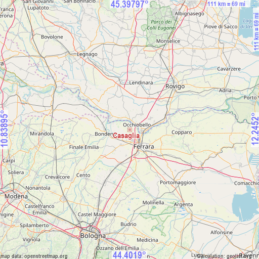
Casaglia GPS coordinates[2]
44° 54' 7.524" North, 11° 32' 31.452" East
| Map corner | latitude | longitude |
|---|---|---|
| Upper-left | 45.39797°, | 10.83895° |
| Center: | 44.90209°, | 11.54207° |
| Lower-right: | 44.4019°, | 12.2452° |
| Map W x H: | 110.8×110.8 km | = 68.8×68.8mi |
| max Lat: | 47.04031° ⇑42.1% North |
| Casaglia: | 44.90209° |
| min Lat: | ⇓57.9% South 35.50142° |
| min Long | Casaglia | max Long |
| 6.69888° | 11.54207° | 18.48682° |
| W 50%⇐ | ⇒50% E |
Elevation
Elevation of Casaglia is 4 m = 13 ft, and this is 302.7 m = 993 ft below average elevation for this country.
| Max E: |
2085 m = 6841 ft | 97.8% |
| Avg. | 306.7 m = 1006 ft | |
| Casaglia | 4 m = 13 ft | |
Min E: |
-4 m = -13 ft | 2.2% |
See also: Italy elevation on elevation.city.
Geographical zone
Casaglia is located in North temperate zone (between Tropic of Cancer and the Arctic Circle). Distance of this Northern Tropic circle is 2386.7 km =1483 mi to South.| Distance of | km | miles | from Casaglia |
|---|---|---|---|
| North Pole | 5014.4 | 3115.8 | to North |
| Arctic Circle | 2408.5 | 1496.6 | to North |
| Tropic Cancer | 2386.7 | 1483 | to South |
| Equator | 4992.6 | 3102.3 | to South |


Nearby cities:
15 places around Casaglia: (largest is in red/bold)
• Bondeno
10.1 km =6.3 mi,  261°
261°
• Canaro
11.1 km =6.9 mi,  71°
71°
• Ferrara
9.4 km =5.8 mi,  139°
139°
• Ficarolo
10.1 km =6.3 mi,  304°
304°
• Fiesso Umbertiano
8.2 km =5.1 mi,  37°
37°
• Francolino
9.1 km =5.7 mi,  93°
93°
• Gaiba
6.8 km =4.2 mi,  315°
315°
• Mirabello
11.1 km =6.9 mi,  217°
217°
• Occhiobello
3.8 km =2.4 mi,  53°
53°
• Porotto-Cassama
5.8 km =3.6 mi,  173°
173°
• Sabbioni-Zampine
5.8 km =3.6 mi,  344°
344°
• Santa Maria Maddalena
5.1 km =3.2 mi, 89°
• Stienta
4.2 km =2.6 mi,  1°
1°
• Vigarano Mainarda
7.8 km =4.8 mi,  209°
209°
• Vigarano Pieve
5.2 km =3.2 mi, 209°
Sources, notices
• [Note1] Compared only with cities in Italy existing in our database
• [Src1] Map data: © OpenStreetMap contributors (CC-BY-SA)
• [Src2] Other city data from geonames.org with taken over terms of usage.
• [Src3] Geographical zone / Annual Mean Temperature by Robert A. Rohde @ Wikipedia
