Gazzo geodata
Gazzo (Lombardy) is a seat of a third-order administrative division; located in Italy in Europe/Rome (GMT+2) time zone. With population of 666 people, there are 8518 cities with bigger population in this country. Compared to other cities in Italy, 64.5% of cities are located further ↓South; 58.5% of cities are located further →East and 86.7% of cities have higher elevation than Gazzo. Note1
Administrative division(s):
- Level 1: Lombardy
- Level 2: Provincia di Mantova
- Level 3: San Giorgio di Mantova


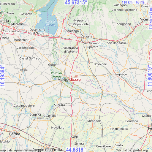
Gazzo GPS coordinates[2]
45° 10' 46.848" North, 10° 53' 49.416" East
| Map corner | latitude | longitude |
|---|---|---|
| Upper-left | 45.67315°, | 10.19394° |
| Center: | 45.17968°, | 10.89706° |
| Lower-right: | 44.6819°, | 11.60019° |
| Map W x H: | 110.2×110.2 km | = 68.5×68.5mi |
| max Lat: | 47.04031° ⇑35.5% North |
| Gazzo: | 45.17968° |
| min Lat: | ⇓64.5% South 35.50142° |
| min Long | Gazzo | max Long |
| 6.69888° | 10.89706° | 18.48682° |
| W 41.5%⇐ | ⇒58.5% E |
Elevation
Elevation of Gazzo is 26 m = 85 ft, and this is 280.7 m = 921 ft below average elevation for this country.
| Max E: |
2085 m = 6841 ft | 86.7% |
| Avg. | 306.7 m = 1006 ft | |
| Gazzo | 26 m = 85 ft | |
Min E: |
-4 m = -13 ft | 13.3% |
See also: Italy elevation on elevation.city.
Geographical zone
Gazzo is located in North temperate zone (between Tropic of Cancer and the Arctic Circle). Distance of this North polar circle is 2377.7 km =1477.4 mi to North.| Distance of | km | miles | from Gazzo |
|---|---|---|---|
| North Pole | 4983.6 | 3096.7 | to North |
| Arctic Circle | 2377.7 | 1477.4 | to North |
| Tropic Cancer | 2417.6 | 1502.2 | to South |
| Equator | 5023.5 | 3121.5 | to South |


Nearby cities:
15 places around Gazzo: (largest is in red/bold)
• Barbasso
6.6 km =4.1 mi,  173°
173°
• Bonferraro
9 km =5.6 mi,  87°
87°
• Castel d'Ario
6.1 km =3.8 mi,  81°
81°
• Castelbelforte
3.6 km =2.2 mi,  354°
354°
• Erbè
9.1 km =5.7 mi,  39°
39°
• Formigosa
6.6 km =4.1 mi,  202°
202°
• Lunetta-Frassino
6.4 km =4 mi,  250°
250°
• Mantova
8.1 km =5 mi, 254°
• Mottella
4.5 km =2.8 mi, 246°
• Pietole
9.6 km =6 mi,  220°
220°
• Roncoferraro
5.8 km =3.6 mi,  142°
142°
• Roncolevà
8 km =5 mi,  7°
7°
• Sant'Antonio
8.3 km =5.2 mi,  283°
283°
• Sorgà
7.5 km =4.7 mi,  60°
60°
• Stradella
2 km =1.2 mi, 246°
Sources, notices
• [Note1] Compared only with cities in Italy existing in our database
• [Src1] Map data: © OpenStreetMap contributors (CC-BY-SA)
• [Src2] Other city data from geonames.org with taken over terms of usage.
• [Src3] Geographical zone / Annual Mean Temperature by Robert A. Rohde @ Wikipedia
