Magione geodata
Magione (Umbria) is a seat of a third-order administrative division; located in Italy in Europe/Rome (GMT+2) time zone. With population of 6,363 people, there are 1538 cities with bigger population in this country. Compared to other cities in Italy, 62.2% of cities are located further ↑North; 58.7% of cities are located further ←West and 50.7% of cities have lower elevation than Magione. Note1


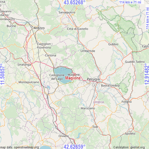
Magione GPS coordinates[2]
43° 8' 30.444" North, 12° 12' 42.084" East
| Map corner | latitude | longitude |
|---|---|---|
| Upper-left | 43.65268°, | 11.50857° |
| Center: | 43.14179°, | 12.21169° |
| Lower-right: | 42.62659°, | 12.91482° |
| Map W x H: | 114.1×114.1 km | = 70.9×70.9mi |
| max Lat: | 47.04031° ⇑62.2% North |
| Magione: | 43.14179° |
| min Lat: | ⇓37.8% South 35.50142° |
| min Long | Magione | max Long |
| 6.69888° | 12.21169° | 18.48682° |
| W 58.7%⇐ | ⇒41.3% E |
Elevation
Elevation of Magione is 239 m = 784 ft, and this is 67.7 m = 222 ft below average elevation for this country.
| Max E: |
2085 m = 6841 ft | 49.3% |
| Avg. | 306.7 m = 1006 ft | |
| Magione | 239 m = 784 ft | |
Min E: |
-4 m = -13 ft | 50.7% |
See also: Italy elevation on elevation.city.
Geographical zone
Magione is located in North temperate zone (between Tropic of Cancer and the Arctic Circle). Distance of this Northern Tropic circle is 2191 km =1361.4 mi to South.| Distance of | km | miles | from Magione |
|---|---|---|---|
| North Pole | 5210.1 | 3237.4 | to North |
| Arctic Circle | 2604.3 | 1618.2 | to North |
| Tropic Cancer | 2191 | 1361.4 | to South |
| Equator | 4796.9 | 2980.7 | to South |


Nearby cities:
15 places around Magione: (largest is in red/bold)
• Agello
8.2 km =5.1 mi,  164°
164°
• Chiugiana-La Commenda
9.2 km =5.7 mi,  121°
121°
• Comparati
9.4 km =5.8 mi,  77°
77°
• Corciano
6.3 km =3.9 mi,  103°
103°
• Il Rigo
8.3 km =5.2 mi, 120°
• Lacugnano
11 km =6.8 mi, 118°
• Mantignana
6.6 km =4.1 mi,  72°
72°
• Mugnano
9.6 km =6 mi,  176°
176°
• Oscano
10.4 km =6.5 mi, 79°
• Passignano sul Trasimeno
8.2 km =5.1 mi,  311°
311°
• San Feliciano
4.5 km =2.8 mi,  233°
233°
• San Pietro
6 km =3.7 mi, 115°
• San Savino
4.1 km =2.5 mi,  201°
201°
• Sant'Arcangelo
7.7 km =4.8 mi,  213°
213°
• Soccorso
2.1 km =1.3 mi, 97°
Sources, notices
• [Note1] Compared only with cities in Italy existing in our database
• [Src1] Map data: © OpenStreetMap contributors (CC-BY-SA)
• [Src2] Other city data from geonames.org with taken over terms of usage.
• [Src3] Geographical zone / Annual Mean Temperature by Robert A. Rohde @ Wikipedia
