Mantignana geodata
Mantignana (Umbria) is a populated place; located in Italy in Europe/Rome (GMT+2) time zone. With population of 2,053 people, there are 4068 cities with bigger population in this country. Compared to other cities in Italy, 62.1% of cities are located further ↑North; 59.7% of cities are located further ←West and 54.3% of cities have lower elevation than Mantignana. Note1


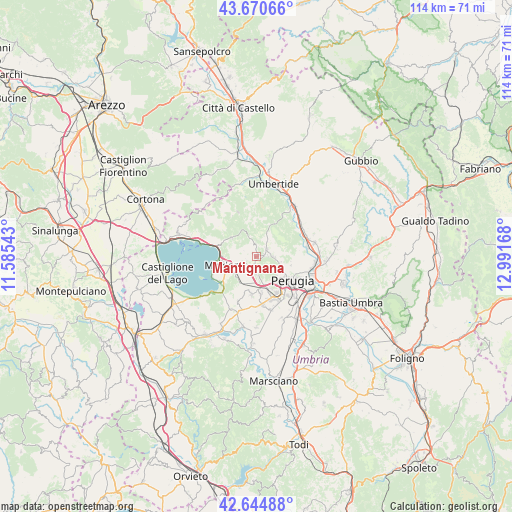
Mantignana GPS coordinates[2]
43° 9' 35.712" North, 12° 17' 18.78" East
| Map corner | latitude | longitude |
|---|---|---|
| Upper-left | 43.67066°, | 11.58543° |
| Center: | 43.15992°, | 12.28855° |
| Lower-right: | 42.64488°, | 12.99168° |
| Map W x H: | 114.1×114.1 km | = 70.9×70.9mi |
| max Lat: | 47.04031° ⇑62.1% North |
| Mantignana: | 43.15992° |
| min Lat: | ⇓37.9% South 35.50142° |
| min Long | Mantignana | max Long |
| 6.69888° | 12.28855° | 18.48682° |
| W 59.7%⇐ | ⇒40.3% E |
Elevation
Elevation of Mantignana is 261 m = 856 ft, and this is 45.7 m = 150 ft below average elevation for this country.
| Max E: |
2085 m = 6841 ft | 45.7% |
| Avg. | 306.7 m = 1006 ft | |
| Mantignana | 261 m = 856 ft | |
Min E: |
-4 m = -13 ft | 54.3% |
See also: Italy elevation on elevation.city.
Geographical zone
Mantignana is located in North temperate zone (between Tropic of Cancer and the Arctic Circle). Distance of this Northern Tropic circle is 2193 km =1362.7 mi to South.| Distance of | km | miles | from Mantignana |
|---|---|---|---|
| North Pole | 5208.1 | 3236.2 | to North |
| Arctic Circle | 2602.2 | 1616.9 | to North |
| Tropic Cancer | 2193 | 1362.7 | to South |
| Equator | 4798.9 | 2981.9 | to South |


Nearby cities:
15 places around Mantignana: (largest is in red/bold)
• Agello
10.7 km =6.6 mi,  202°
202°
• Chiugiana-La Commenda
7 km =4.3 mi,  166°
166°
• Comparati
2.9 km =1.8 mi,  90°
90°
• Corciano
3.5 km =2.2 mi,  182°
182°
• Il Rigo
6.3 km =3.9 mi, 171°
• Lacugnano
8 km =5 mi,  154°
154°
• Magione
6.6 km =4.1 mi,  252°
252°
• Oliveto
7.7 km =4.8 mi,  121°
121°
• Oscano
4 km =2.5 mi, 92°
• Perugia
9.7 km =6 mi, 123°
• San Feliciano
10.9 km =6.8 mi,  244°
244°
• San Pietro
4.6 km =2.9 mi,  190°
190°
• San Savino
9.7 km =6 mi,  233°
233°
• Soccorso
4.7 km =2.9 mi, 240°
• bishopric of Perugia
9.7 km =6 mi, 122°
Sources, notices
• [Note1] Compared only with cities in Italy existing in our database
• [Src1] Map data: © OpenStreetMap contributors (CC-BY-SA)
• [Src2] Other city data from geonames.org with taken over terms of usage.
• [Src3] Geographical zone / Annual Mean Temperature by Robert A. Rohde @ Wikipedia
