Genoa geodata
Genoa (Liguria) is a seat of a first-order administrative division; located in Italy in Europe/Rome (GMT+2) time zone. With population of 580,223 people, there are 5 cities with bigger population in this country. Compared to other cities in Italy, 50.4% of cities are located further ↑North; 82% of cities are located further →East and 90.6% of cities have higher elevation than Genoa. Note1


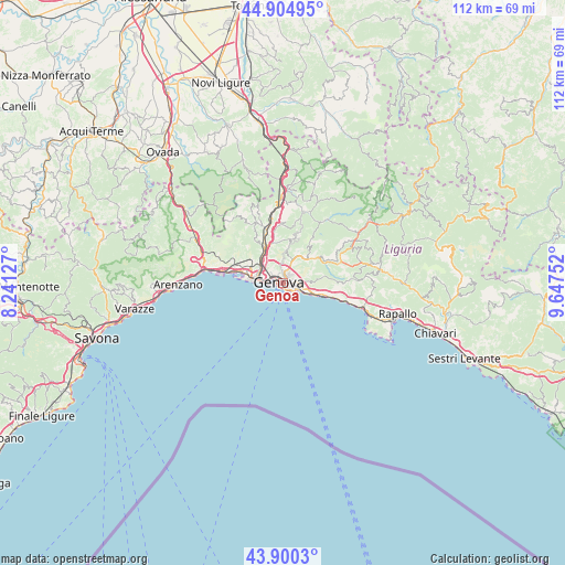
Genoa GPS coordinates[2]
44° 24' 17.208" North, 8° 56' 39.804" East
| Map corner | latitude | longitude |
|---|---|---|
| Upper-left | 44.90495°, | 8.24127° |
| Center: | 44.40478°, | 8.94439° |
| Lower-right: | 43.9003°, | 9.64752° |
| Map W x H: | 111.7×111.7 km | = 69.4×69.4mi |
| max Lat: | 47.04031° ⇑50.4% North |
| Genoa: | 44.40478° |
| min Lat: | ⇓49.6% South 35.50142° |
| min Long | Genoa | max Long |
| 6.69888° | 8.94439° | 18.48682° |
| W 18%⇐ | ⇒82% E |
Elevation
Elevation of Genoa is 17 m = 56 ft, and this is 289.7 m = 950 ft below average elevation for this country.
| Max E: |
2085 m = 6841 ft | 90.6% |
| Avg. | 306.7 m = 1006 ft | |
| Genoa | 17 m = 56 ft | |
Min E: |
-4 m = -13 ft | 9.4% |
See also: Genoa elevation on elevation.city.
Geographical zone
Genoa is located in North temperate zone (between Tropic of Cancer and the Arctic Circle). Distance of this Northern Tropic circle is 2331.4 km =1448.7 mi to South.| Distance of | km | miles | from Genoa |
|---|---|---|---|
| North Pole | 5069.7 | 3150.2 | to North |
| Arctic Circle | 2463.8 | 1530.9 | to North |
| Tropic Cancer | 2331.4 | 1448.7 | to South |
| Equator | 4937.3 | 3067.9 | to South |


Nearby cities:
15 places around Genoa: (largest is in red/bold)
• Bargagli
12.8 km =8 mi,  68°
68°
• Bogliasco
10.3 km =6.4 mi,  105°
105°
• Campomorone
12.6 km =7.8 mi,  337°
337°
• Ceranesi
11.9 km =7.4 mi, 340°
• Ferriera-Pontasso
13.1 km =8.1 mi, 336°
• Gaiazza
12.5 km =7.8 mi,  332°
332°
• Manesseno
8.3 km =5.2 mi,  350°
350°
• Pedemonte
11 km =6.8 mi, 352°
• Piccarello
9 km =5.6 mi,  11°
11°
• Pieve Ligure
12.3 km =7.6 mi, 105°
• Poggio Favaro-San Bernardo
11 km =6.8 mi,  102°
102°
• Prelo
11.7 km =7.3 mi, 348°
• San Teodoro
2.9 km =1.8 mi,  291°
291°
• Santa Marta
11.8 km =7.3 mi, 339°
• Serra Riccò
11.8 km =7.3 mi,  357°
357°
In other languages:
- In Spanish: Génova
- In France: Gênes
- In German: Genua
- In Italian: Genova
- In Russian: Генуя
Sources, notices
• [Note1] Compared only with cities in Italy existing in our database
• [Src1] Map data: © OpenStreetMap contributors (CC-BY-SA)
• [Src2] Other city data from geonames.org with taken over terms of usage.
• [Src3] Geographical zone / Annual Mean Temperature by Robert A. Rohde @ Wikipedia
