Pedemonte geodata
Pedemonte (Liguria) is a seat of a third-order administrative division; located in Italy in Europe/Rome (GMT+2) time zone. With population of 5,824 people, there are 1683 cities with bigger population in this country. Compared to other cities in Italy, 51.1% of cities are located further ↓South; 82.3% of cities are located further →East and 64.9% of cities have higher elevation than Pedemonte. Note1


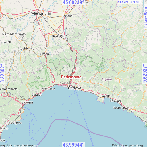
Pedemonte GPS coordinates[2]
44° 30' 11.052" North, 8° 55' 34.104" East
| Map corner | latitude | longitude |
|---|---|---|
| Upper-left | 45.00239°, | 8.22302° |
| Center: | 44.50307°, | 8.92614° |
| Lower-right: | 43.99944°, | 9.62927° |
| Map W x H: | 111.5×111.5 km | = 69.3×69.3mi |
| max Lat: | 47.04031° ⇑48.9% North |
| Pedemonte: | 44.50307° |
| min Lat: | ⇓51.1% South 35.50142° |
| min Long | Pedemonte | max Long |
| 6.69888° | 8.92614° | 18.48682° |
| W 17.7%⇐ | ⇒82.3% E |
Elevation
Elevation of Pedemonte is 128 m = 420 ft, and this is 178.7 m = 586 ft below average elevation for this country.
| Max E: |
2085 m = 6841 ft | 64.9% |
| Avg. | 306.7 m = 1006 ft | |
| Pedemonte | 128 m = 420 ft | |
Min E: |
-4 m = -13 ft | 35.1% |
See also: Italy elevation on elevation.city.
Geographical zone
Pedemonte is located in North temperate zone (between Tropic of Cancer and the Arctic Circle). Distance of this Northern Tropic circle is 2342.4 km =1455.5 mi to South.| Distance of | km | miles | from Pedemonte |
|---|---|---|---|
| North Pole | 5058.8 | 3143.4 | to North |
| Arctic Circle | 2452.9 | 1524.2 | to North |
| Tropic Cancer | 2342.4 | 1455.5 | to South |
| Equator | 4948.3 | 3074.7 | to South |


Nearby cities:
15 places around Pedemonte: (largest is in red/bold)
• Busalla
7.7 km =4.8 mi,  11°
11°
• Campomorone
3.3 km =2.1 mi,  282°
282°
• Casella
6.9 km =4.3 mi,  58°
58°
• Ceranesi
2.6 km =1.6 mi, 276°
• Ferriera-Pontasso
4 km =2.5 mi, 284°
• Gaiazza
4.3 km =2.7 mi,  272°
272°
• Isorelle
7.7 km =4.8 mi,  21°
21°
• Isoverde
6 km =3.7 mi,  299°
299°
• Manesseno
2.8 km =1.7 mi,  177°
177°
• Mignanego
2.9 km =1.8 mi,  340°
340°
• Piccarello
3.8 km =2.4 mi,  123°
123°
• Prelo
1.1 km =0.7 mi, 301°
• Santa Marta
2.7 km =1.7 mi, 272°
• Savignone
8.4 km =5.2 mi,  35°
35°
• Serra Riccò
1.3 km =0.8 mi,  48°
48°
Sources, notices
• [Note1] Compared only with cities in Italy existing in our database
• [Src1] Map data: © OpenStreetMap contributors (CC-BY-SA)
• [Src2] Other city data from geonames.org with taken over terms of usage.
• [Src3] Geographical zone / Annual Mean Temperature by Robert A. Rohde @ Wikipedia
