Gaiazza geodata
Gaiazza (Liguria) is a populated place; located in Italy in Europe/Rome (GMT+2) time zone. With population of 556 people, there are 9392 cities with bigger population in this country. Compared to other cities in Italy, 51.1% of cities are located further ↓South; 83.2% of cities are located further →East and 62% of cities have lower elevation than Gaiazza. Note1


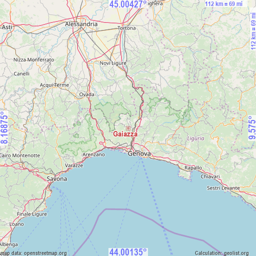
Gaiazza GPS coordinates[2]
44° 30' 17.892" North, 8° 52' 18.732" East
| Map corner | latitude | longitude |
|---|---|---|
| Upper-left | 45.00427°, | 8.16875° |
| Center: | 44.50497°, | 8.87187° |
| Lower-right: | 44.00135°, | 9.575° |
| Map W x H: | 111.5×111.5 km | = 69.3×69.3mi |
| max Lat: | 47.04031° ⇑48.9% North |
| Gaiazza: | 44.50497° |
| min Lat: | ⇓51.1% South 35.50142° |
| min Long | Gaiazza | max Long |
| 6.69888° | 8.87187° | 18.48682° |
| W 16.8%⇐ | ⇒83.2% E |
Elevation
Elevation of Gaiazza is 315 m = 1033 ft, and this is 8.3 m = 27 ft above average elevation for this country.
| Max E: |
2085 m = 6841 ft | 38% |
| Gaiazza | 315 m 1033 ft | |
| Avg. | 306.7 m = 1006 ft | |
Min E: |
-4 m = -13 ft | 62% |
See also: Italy elevation on elevation.city.
Geographical zone
Gaiazza is located in North temperate zone (between Tropic of Cancer and the Arctic Circle). Distance of this Northern Tropic circle is 2342.6 km =1455.6 mi to South.| Distance of | km | miles | from Gaiazza |
|---|---|---|---|
| North Pole | 5058.6 | 3143.3 | to North |
| Arctic Circle | 2452.7 | 1524 | to North |
| Tropic Cancer | 2342.6 | 1455.6 | to South |
| Equator | 4948.5 | 3074.9 | to South |


Nearby cities:
15 places around Gaiazza: (largest is in red/bold)
• Busalla
9.3 km =5.8 mi,  38°
38°
• Campomorone
1.2 km =0.7 mi,  64°
64°
• Ceranesi
1.7 km =1.1 mi,  87°
87°
• Ferriera-Pontasso
0.9 km =0.6 mi,  27°
27°
• Fraconalto
9.6 km =6 mi,  3°
3°
• Isorelle
9.9 km =6.2 mi,  45°
45°
• Isoverde
2.9 km =1.8 mi,  341°
341°
• Manesseno
5.3 km =3.3 mi,  123°
123°
• Mignanego
4.2 km =2.6 mi, 53°
• Pedemonte
4.3 km =2.7 mi, 92°
• Piccarello
7.8 km =4.8 mi,  107°
107°
• Prelo
3.4 km =2.1 mi,  83°
83°
• San Teodoro
10.5 km =6.5 mi,  163°
163°
• Santa Marta
1.7 km =1.1 mi, 93°
• Serra Riccò
5.3 km =3.3 mi, 83°
Sources, notices
• [Note1] Compared only with cities in Italy existing in our database
• [Src1] Map data: © OpenStreetMap contributors (CC-BY-SA)
• [Src2] Other city data from geonames.org with taken over terms of usage.
• [Src3] Geographical zone / Annual Mean Temperature by Robert A. Rohde @ Wikipedia
