San Teodoro geodata
San Teodoro (Liguria) is a seat of a third-order administrative division; located in Italy in Europe/Rome (GMT+2) time zone. In our database, there are 11707 cities with bigger population. Compared to other cities in Italy, 50.2% of cities are located further ↑North; 82.6% of cities are located further →East and 87% of cities have higher elevation than San Teodoro. Note1


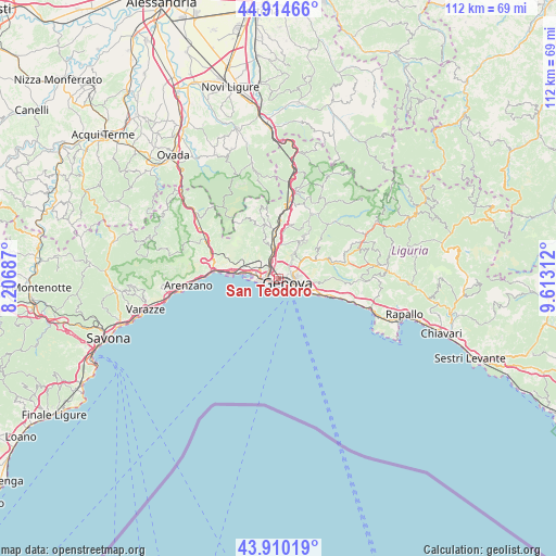
San Teodoro GPS coordinates[2]
44° 24' 52.488" North, 8° 54' 36" East
| Map corner | latitude | longitude |
|---|---|---|
| Upper-left | 44.91466°, | 8.20687° |
| Center: | 44.41458°, | 8.91° |
| Lower-right: | 43.91019°, | 9.61312° |
| Map W x H: | 111.7×111.7 km | = 69.4×69.4mi |
| max Lat: | 47.04031° ⇑50.2% North |
| San Teodoro: | 44.41458° |
| min Lat: | ⇓49.8% South 35.50142° |
| min Long | San Teodoro | max Long |
| 6.69888° | 8.91° | 18.48682° |
| W 17.4%⇐ | ⇒82.6% E |
Elevation
Elevation of San Teodoro is 25 m = 82 ft, and this is 281.7 m = 924 ft below average elevation for this country.
| Max E: |
2085 m = 6841 ft | 87% |
| Avg. | 306.7 m = 1006 ft | |
| San Teodoro | 25 m = 82 ft | |
Min E: |
-4 m = -13 ft | 13% |
See also: Italy elevation on elevation.city.
Geographical zone
San Teodoro is located in North temperate zone (between Tropic of Cancer and the Arctic Circle). Distance of this Northern Tropic circle is 2332.5 km =1449.3 mi to South.| Distance of | km | miles | from San Teodoro |
|---|---|---|---|
| North Pole | 5068.6 | 3149.5 | to North |
| Arctic Circle | 2462.7 | 1530.3 | to North |
| Tropic Cancer | 2332.5 | 1449.3 | to South |
| Equator | 4938.4 | 3068.6 | to South |


Nearby cities:
15 places around San Teodoro: (largest is in red/bold)
• Bogliasco
13.2 km =8.2 mi,  106°
106°
• Campomorone
10.7 km =6.6 mi,  349°
349°
• Ceranesi
10.2 km =6.3 mi, 352°
• Ferriera-Pontasso
11.2 km =7 mi, 346°
• Gaiazza
10.5 km =6.5 mi,  343°
343°
• Genoa
2.9 km =1.8 mi, 111°
• Isoverde
13.4 km =8.3 mi, 342°
• Manesseno
7.2 km =4.5 mi,  11°
11°
• Mele
13.3 km =8.3 mi,  285°
285°
• Mignanego
12.6 km =7.8 mi,  1°
1°
• Pedemonte
9.9 km =6.2 mi, 7°
• Piccarello
8.9 km =5.5 mi,  29°
29°
• Prelo
10.4 km =6.5 mi, 1°
• Santa Marta
10 km =6.2 mi, 352°
• Serra Riccò
10.9 km =6.8 mi, 11°
Sources, notices
• [Note1] Compared only with cities in Italy existing in our database
• [Src1] Map data: © OpenStreetMap contributors (CC-BY-SA)
• [Src2] Other city data from geonames.org with taken over terms of usage.
• [Src3] Geographical zone / Annual Mean Temperature by Robert A. Rohde @ Wikipedia
