Gabbioneta geodata
Gabbioneta (Lombardy) is a seat of a third-order administrative division; located in Italy in Europe/Rome (GMT+2) time zone. With population of 409 people, there are 10241 cities with bigger population in this country. Compared to other cities in Italy, 65.3% of cities are located further ↓South; 65.8% of cities are located further →East and 83.4% of cities have higher elevation than Gabbioneta. Note1
Administrative division(s):
- Level 1: Lombardy
- Level 2: Provincia di Cremona
- Level 3: Gabbioneta-Binanuova


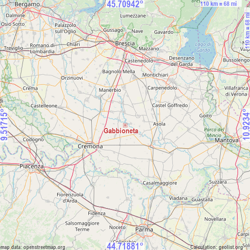
Gabbioneta GPS coordinates[2]
45° 12' 58.572" North, 10° 13' 12.972" East
| Map corner | latitude | longitude |
|---|---|---|
| Upper-left | 45.70942°, | 9.51715° |
| Center: | 45.21627°, | 10.22027° |
| Lower-right: | 44.71881°, | 10.9234° |
| Map W x H: | 110.1×110.1 km | = 68.4×68.4mi |
| max Lat: | 47.04031° ⇑34.7% North |
| Gabbioneta: | 45.21627° |
| min Lat: | ⇓65.3% South 35.50142° |
| min Long | Gabbioneta | max Long |
| 6.69888° | 10.22027° | 18.48682° |
| W 34.2%⇐ | ⇒65.8% E |
Elevation
Elevation of Gabbioneta is 36 m = 118 ft, and this is 270.7 m = 888 ft below average elevation for this country.
| Max E: |
2085 m = 6841 ft | 83.4% |
| Avg. | 306.7 m = 1006 ft | |
| Gabbioneta | 36 m = 118 ft | |
Min E: |
-4 m = -13 ft | 16.6% |
See also: Italy elevation on elevation.city.
Geographical zone
Gabbioneta is located in North temperate zone (between Tropic of Cancer and the Arctic Circle). Distance of this North polar circle is 2373.6 km =1474.9 mi to North.| Distance of | km | miles | from Gabbioneta |
|---|---|---|---|
| North Pole | 4979.5 | 3094.1 | to North |
| Arctic Circle | 2373.6 | 1474.9 | to North |
| Tropic Cancer | 2421.7 | 1504.8 | to South |
| Equator | 5027.6 | 3124 | to South |


Nearby cities:
15 places around Gabbioneta: (largest is in red/bold)
• Alfianello
8 km =5 mi,  314°
314°
• Cappella de' Picenardi
6.5 km =4 mi,  173°
173°
• Cicognolo
5.8 km =3.6 mi,  200°
200°
• Fiesse
8.3 km =5.2 mi,  77°
77°
• Gambara
7.1 km =4.4 mi,  54°
54°
• Grontardo
5.6 km =3.5 mi,  252°
252°
• Milzano
6.6 km =4.1 mi,  345°
345°
• Ostiano
2.8 km =1.7 mi, 75°
• Pescarolo
3.6 km =2.2 mi,  226°
226°
• Pessina Cremonese
4.1 km =2.5 mi,  147°
147°
• Pralboino
5.7 km =3.5 mi,  358°
358°
• Scandolara Ripa d'Oglio
5 km =3.1 mi,  276°
276°
• Seniga
4.6 km =2.9 mi, 313°
• Vescovato
6.4 km =4 mi,  223°
223°
• Volongo
6.5 km =4 mi,  94°
94°
Sources, notices
• [Note1] Compared only with cities in Italy existing in our database
• [Src1] Map data: © OpenStreetMap contributors (CC-BY-SA)
• [Src2] Other city data from geonames.org with taken over terms of usage.
• [Src3] Geographical zone / Annual Mean Temperature by Robert A. Rohde @ Wikipedia
