Ostiano geodata
Ostiano (Lombardy) is a seat of a third-order administrative division; located in Italy in Europe/Rome (GMT+2) time zone. With population of 2,808 people, there are 3206 cities with bigger population in this country. Compared to other cities in Italy, 65.5% of cities are located further ↓South; 65.5% of cities are located further →East and 83.1% of cities have higher elevation than Ostiano. Note1


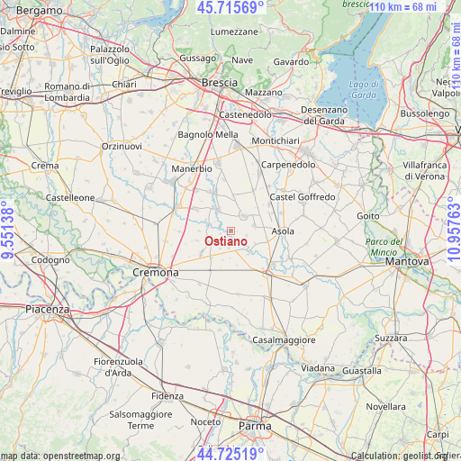
Ostiano GPS coordinates[2]
45° 13' 21.36" North, 10° 15' 16.2" East
| Map corner | latitude | longitude |
|---|---|---|
| Upper-left | 45.71569°, | 9.55138° |
| Center: | 45.2226°, | 10.2545° |
| Lower-right: | 44.72519°, | 10.95763° |
| Map W x H: | 110.1×110.1 km | = 68.4×68.4mi |
| max Lat: | 47.04031° ⇑34.5% North |
| Ostiano: | 45.2226° |
| min Lat: | ⇓65.5% South 35.50142° |
| min Long | Ostiano | max Long |
| 6.69888° | 10.2545° | 18.48682° |
| W 34.5%⇐ | ⇒65.5% E |
Elevation
Elevation of Ostiano is 37 m = 121 ft, and this is 269.7 m = 885 ft below average elevation for this country.
| Max E: |
2085 m = 6841 ft | 83.1% |
| Avg. | 306.7 m = 1006 ft | |
| Ostiano | 37 m = 121 ft | |
Min E: |
-4 m = -13 ft | 16.9% |
See also: Italy elevation on elevation.city.
Geographical zone
Ostiano is located in North temperate zone (between Tropic of Cancer and the Arctic Circle). Distance of this North polar circle is 2372.9 km =1474.5 mi to North.| Distance of | km | miles | from Ostiano |
|---|---|---|---|
| North Pole | 4978.8 | 3093.7 | to North |
| Arctic Circle | 2372.9 | 1474.5 | to North |
| Tropic Cancer | 2422.4 | 1505.2 | to South |
| Equator | 5028.3 | 3124.4 | to South |


Nearby cities:
15 places around Ostiano: (largest is in red/bold)
• Cappella de' Picenardi
7.4 km =4.6 mi,  195°
195°
• Cicognolo
7.7 km =4.8 mi,  217°
217°
• Fiesse
5.6 km =3.5 mi,  79°
79°
• Gabbioneta
2.8 km =1.7 mi,  255°
255°
• Gambara
4.7 km =2.9 mi,  42°
42°
• Gottolengo
7.9 km =4.9 mi,  8°
8°
• Grontardo
8.4 km =5.2 mi,  253°
253°
• Isola Dovarese
7 km =4.3 mi,  142°
142°
• Milzano
7.1 km =4.4 mi,  322°
322°
• Pescarolo
6.2 km =3.9 mi,  239°
239°
• Pessina Cremonese
4.2 km =2.6 mi,  186°
186°
• Pralboino
5.7 km =3.5 mi,  330°
330°
• Scandolara Ripa d'Oglio
7.6 km =4.7 mi,  269°
269°
• Seniga
6.5 km =4 mi,  292°
292°
• Volongo
3.9 km =2.4 mi,  108°
108°
Sources, notices
• [Note1] Compared only with cities in Italy existing in our database
• [Src1] Map data: © OpenStreetMap contributors (CC-BY-SA)
• [Src2] Other city data from geonames.org with taken over terms of usage.
• [Src3] Geographical zone / Annual Mean Temperature by Robert A. Rohde @ Wikipedia
