Magreta geodata
Magreta (Emilia-Romagna) is a populated place; located in Italy in Europe/Rome (GMT+2) time zone. With population of 3,344 people, there are 2805 cities with bigger population in this country. Compared to other cities in Italy, 52.5% of cities are located further ↓South; 59.7% of cities are located further →East and 74.3% of cities have higher elevation than Magreta. Note1


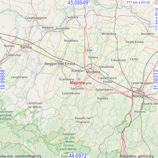
Magreta GPS coordinates[2]
44° 36' 0" North, 10° 48' 0" East
| Map corner | latitude | longitude |
|---|---|---|
| Upper-left | 45.09849°, | 10.09688° |
| Center: | 44.6°, | 10.8° |
| Lower-right: | 44.0972°, | 11.50313° |
| Map W x H: | 111.3×111.3 km | = 69.2×69.2mi |
| max Lat: | 47.04031° ⇑47.5% North |
| Magreta: | 44.6° |
| min Lat: | ⇓52.5% South 35.50142° |
| min Long | Magreta | max Long |
| 6.69888° | 10.8° | 18.48682° |
| W 40.3%⇐ | ⇒59.7% E |
Elevation
Elevation of Magreta is 77 m = 253 ft, and this is 229.7 m = 754 ft below average elevation for this country.
| Max E: |
2085 m = 6841 ft | 74.3% |
| Avg. | 306.7 m = 1006 ft | |
| Magreta | 77 m = 253 ft | |
Min E: |
-4 m = -13 ft | 25.7% |
See also: Italy elevation on elevation.city.
Geographical zone
Magreta is located in North temperate zone (between Tropic of Cancer and the Arctic Circle). Distance of this Northern Tropic circle is 2353.1 km =1462.1 mi to South.| Distance of | km | miles | from Magreta |
|---|---|---|---|
| North Pole | 5048 | 3136.7 | to North |
| Arctic Circle | 2442.1 | 1517.5 | to North |
| Tropic Cancer | 2353.1 | 1462.1 | to South |
| Equator | 4959.1 | 3081.4 | to South |


Nearby cities:
15 places around Magreta: (largest is in red/bold)
• Arceto
6.3 km =3.9 mi,  288°
288°
• Baggiovara
5 km =3.1 mi,  84°
84°
• Bagno
7 km =4.3 mi,  332°
332°
• Cadiroggio
7.2 km =4.5 mi,  218°
218°
• Casalgrande
5.4 km =3.4 mi,  251°
251°
• Corticella
5.4 km =3.4 mi,  315°
315°
• Fellegara
8.2 km =5.1 mi,  278°
278°
• Fiorano
6.9 km =4.3 mi,  172°
172°
• Fontana
8.6 km =5.3 mi,  1°
1°
• Formigine
4.8 km =3 mi,  129°
129°
• Rubiera
6 km =3.7 mi,  344°
344°
• Salvaterra
2.5 km =1.6 mi,  268°
268°
• Sassuolo
6.4 km =4 mi,  190°
190°
• Scandiano
8.3 km =5.2 mi, 268°
• Veggia-Villalunga
5.6 km =3.5 mi, 218°
Sources, notices
• [Note1] Compared only with cities in Italy existing in our database
• [Src1] Map data: © OpenStreetMap contributors (CC-BY-SA)
• [Src2] Other city data from geonames.org with taken over terms of usage.
• [Src3] Geographical zone / Annual Mean Temperature by Robert A. Rohde @ Wikipedia
