Abbadia San Salvatore geodata
Abbadia San Salvatore (Tuscany) is a seat of a third-order administrative division; located in Italy in Europe/Rome (GMT+2) time zone. With population of 6,364 people, there are 1537 cities with bigger population in this country. Compared to other cities in Italy, 64.1% of cities are located further ↑North; 51.5% of cities are located further ←West and 93.9% of cities have lower elevation than Abbadia San Salvatore. Note1
Administrative division(s):
- Level 1: Tuscany
- Level 2: Provincia di Siena
- Level 3: Abbadia San Salvatore
Current local time in Abbadia San Salvatore:
10:16 PM, WednesdayDifference from your time zone: hours


Abbadia San Salvatore GPS coordinates[2]
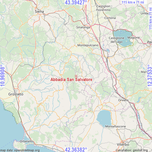
42° 52' 52.32" North, 11° 40' 19.92" East
| Map corner | latitude | longitude |
|---|---|---|
| Upper-left | 43.39427°, | 10.96908° |
| Center: | 42.8812°, | 11.6722° |
| Lower-right: | 42.36382°, | 12.37533° |
| Map W x H: | 114.6×114.6 km | = 71.2×71.2mi |
| max Lat: | 47.04031° ⇑64.1% North |
| Abbadia San Salvatore: | 42.8812° |
| min Lat: | ⇓35.9% South 35.50142° |
| min Long | Abbadia San Sal | max Long |
| 6.69888° | 11.6722° | 18.48682° |
| W 51.5%⇐ | ⇒48.5% E |
Elevation
Elevation of Abbadia San Salvatore is 836 m = 2743 ft, and this is 529.3 m = 1737 ft above average elevation for this country.
| Max E: |
2085 m = 6841 ft | 6.1% |
| Abbadia San Salvatore | 836 m 2743 ft | |
| Avg. | 306.7 m = 1006 ft | |
Min E: |
-4 m = -13 ft | 93.9% |
See also: Italy elevation on elevation.city.
Geographical zone
Abbadia San Salvatore is located in North temperate zone (between Tropic of Cancer and the Arctic Circle). Distance of this Northern Tropic circle is 2162 km =1343.4 mi to South.| Distance of | km | miles | from Abbadia San Salvatore |
|---|---|---|---|
| North Pole | 5239.1 | 3255.4 | to North |
| Arctic Circle | 2633.2 | 1636.2 | to North |
| Tropic Cancer | 2162 | 1343.4 | to South |
| Equator | 4767.9 | 2962.6 | to South |


Nearby cities:
15 places around Abbadia San Salvatore: (largest is in red/bold)
• Arcidosso
11.1 km =6.9 mi,  264°
264°
• Bagnolo
6.3 km =3.9 mi,  224°
224°
• Castel del Piano
10.9 km =6.8 mi,  276°
276°
• Castell'Azzara
12.2 km =7.6 mi,  170°
170°
• Castiglione d'Orcia
14.5 km =9 mi,  341°
341°
• Piancastagnaio
3.7 km =2.3 mi,  156°
156°
• Proceno
18.8 km =11.7 mi,  137°
137°
• Radicofani
8 km =5 mi,  78°
78°
• Roccalbegna
17.1 km =10.6 mi,  231°
231°
• San Casciano dei Bagni
16.7 km =10.4 mi,  94°
94°
• Santa Fiora
9 km =5.6 mi, 232°
• Sarteano
19.9 km =12.4 mi,  51°
51°
• Seggiano
10.8 km =6.7 mi,  299°
299°
• Semproniano
20 km =12.4 mi,  212°
212°
• Vivo d'Orcia
6.1 km =3.8 mi, 336°
Sources, notices
• [Note1] Compared only with cities in Italy existing in our database
• [Src1] Map data: © OpenStreetMap contributors (CC-BY-SA)
• [Src2] Other city data from geonames.org with taken over terms of usage.
• [Src3] Geographical zone / Annual Mean Temperature by Robert A. Rohde @ Wikipedia
