Pertegada geodata
Pertegada (Friuli Venezia Giulia) is a populated place; located in Italy in Europe/Rome (GMT+2) time zone. With population of 1,899 people, there are 4317 cities with bigger population in this country. Compared to other cities in Italy, 82.3% of cities are located further ↓South; 68.8% of cities are located further ←West and 99% of cities have higher elevation than Pertegada. Note1
Administrative division(s):
- Level 1: Friuli Venezia Giulia
- Level 2: Provincia di Udine
- Level 3: Latisana


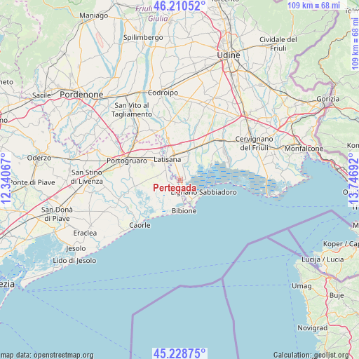
Pertegada GPS coordinates[2]
45° 43' 18.444" North, 13° 2' 37.644" East
| Map corner | latitude | longitude |
|---|---|---|
| Upper-left | 46.21052°, | 12.34067° |
| Center: | 45.72179°, | 13.04379° |
| Lower-right: | 45.22875°, | 13.74692° |
| Map W x H: | 109.2×109.2 km | = 67.9×67.9mi |
| max Lat: | 47.04031° ⇑17.7% North |
| Pertegada: | 45.72179° |
| min Lat: | ⇓82.3% South 35.50142° |
| min Long | Pertegada | max Long |
| 6.69888° | 13.04379° | 18.48682° |
| W 68.8%⇐ | ⇒31.2% E |
Elevation
Elevation of Pertegada is 2 m = 7 ft, and this is 304.7 m = 1000 ft below average elevation for this country.
| Max E: |
2085 m = 6841 ft | 99% |
| Avg. | 306.7 m = 1006 ft | |
| Pertegada | 2 m = 7 ft | |
Min E: |
-4 m = -13 ft | 1% |
See also: Italy elevation on elevation.city.
Geographical zone
Pertegada is located in North temperate zone (between Tropic of Cancer and the Arctic Circle). Distance of this North polar circle is 2317.4 km =1440 mi to North.| Distance of | km | miles | from Pertegada |
|---|---|---|---|
| North Pole | 4923.3 | 3059.2 | to North |
| Arctic Circle | 2317.4 | 1440 | to North |
| Tropic Cancer | 2477.9 | 1539.7 | to South |
| Equator | 5083.8 | 3158.9 | to South |


Nearby cities:
15 places around Pertegada: (largest is in red/bold)
• Bibione
9.6 km =6 mi,  183°
183°
• Casale della Madonna
11.4 km =7.1 mi,  57°
57°
• Cesarolo
2.2 km =1.4 mi,  261°
261°
• Gorgo
3.2 km =2 mi,  331°
331°
• Latisana
6 km =3.7 mi, 330°
• Lignano Sabbiadoro
7.7 km =4.8 mi,  131°
131°
• Lugugnana
6.6 km =4.1 mi,  280°
280°
• Marano Lagunare
10.7 km =6.6 mi, 64°
• Muzzana del Turgnano
12.5 km =7.8 mi,  31°
31°
• Palazzolo dello Stella
9.2 km =5.7 mi,  21°
21°
• Precenicco
8.7 km =5.4 mi, 16°
• Rivarotta
11.4 km =7.1 mi,  14°
14°
• Ronchis
10.3 km =6.4 mi,  338°
338°
• San Giorgio al Tagliamento-Pozzi
10.4 km =6.5 mi,  323°
323°
• San Michele al Tagliamento
6.1 km =3.8 mi, 321°
Sources, notices
• [Note1] Compared only with cities in Italy existing in our database
• [Src1] Map data: © OpenStreetMap contributors (CC-BY-SA)
• [Src2] Other city data from geonames.org with taken over terms of usage.
• [Src3] Geographical zone / Annual Mean Temperature by Robert A. Rohde @ Wikipedia
