Fluminimaggiore geodata
Fluminimaggiore (Sardinia) is a seat of a third-order administrative division; located in Italy in Europe/Rome (GMT+2) time zone. With population of 2,812 people, there are 3202 cities with bigger population in this country. Compared to other cities in Italy, 90.6% of cities are located further ↑North; 88% of cities are located further →East and 73.8% of cities have higher elevation than Fluminimaggiore. Note1
Administrative division(s):
- Level 1: Sardinia
- Level 2: Provincia del Sud Sardegna
- Level 3: Fluminimaggiore


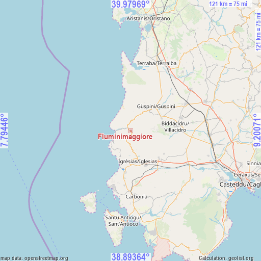
Fluminimaggiore GPS coordinates[2]
39° 26' 19.608" North, 8° 29' 51.288" East
| Map corner | latitude | longitude |
|---|---|---|
| Upper-left | 39.97969°, | 7.79446° |
| Center: | 39.43878°, | 8.49758° |
| Lower-right: | 38.89364°, | 9.20071° |
| Map W x H: | 120.8×120.8 km | = 75.1×75.1mi |
| max Lat: | 47.04031° ⇑90.6% North |
| Fluminimaggiore: | 39.43878° |
| min Lat: | ⇓9.4% South 35.50142° |
| min Long | Fluminimaggiore | max Long |
| 6.69888° | 8.49758° | 18.48682° |
| W 12%⇐ | ⇒88% E |
Elevation
Elevation of Fluminimaggiore is 79 m = 259 ft, and this is 227.7 m = 747 ft below average elevation for this country.
| Max E: |
2085 m = 6841 ft | 73.8% |
| Avg. | 306.7 m = 1006 ft | |
| Fluminimaggiore | 79 m = 259 ft | |
Min E: |
-4 m = -13 ft | 26.2% |
See also: Italy elevation on elevation.city.
Geographical zone
Fluminimaggiore is located in North temperate zone (between Tropic of Cancer and the Arctic Circle). Distance of this Northern Tropic circle is 1779.3 km =1105.6 mi to South.| Distance of | km | miles | from Fluminimaggiore |
|---|---|---|---|
| North Pole | 5621.9 | 3493.3 | to North |
| Arctic Circle | 3016 | 1874.1 | to North |
| Tropic Cancer | 1779.3 | 1105.6 | to South |
| Equator | 4385.2 | 2724.8 | to South |


Nearby cities:
15 places around Fluminimaggiore: (largest is in red/bold)
• Arbus
13.1 km =8.1 mi,  42°
42°
• Bacu Abis
21.9 km =13.6 mi,  187°
187°
• Buggerru
9.4 km =5.8 mi,  241°
241°
• Cortoghiana
25.4 km =15.8 mi, 186°
• Domusnovas
18.2 km =11.3 mi,  134°
134°
• Gonnesa
19.4 km =12.1 mi, 186°
• Gonnosfanadiga
15.4 km =9.6 mi,  66°
66°
• Guspini
16.3 km =10.1 mi,  46°
46°
• Iglesias
14.8 km =9.2 mi,  166°
166°
• Musei
21 km =13 mi,  136°
136°
• Nebida
14.8 km =9.2 mi,  200°
200°
• Nuraxi Figus
24.7 km =15.3 mi, 192°
• Pabillonis
25.7 km =16 mi, 48°
• Villacidro
21 km =13 mi,  84°
84°
• Villamassargia
22 km =13.7 mi,  145°
145°
Sources, notices
• [Note1] Compared only with cities in Italy existing in our database
• [Src1] Map data: © OpenStreetMap contributors (CC-BY-SA)
• [Src2] Other city data from geonames.org with taken over terms of usage.
• [Src3] Geographical zone / Annual Mean Temperature by Robert A. Rohde @ Wikipedia
