La Villa geodata
La Villa (Trentino-Alto Adige) is a populated place; located in Italy in Europe/Rome (GMT+2) time zone. With population of 904 people, there are 7124 cities with bigger population in this country. Compared to other cities in Italy, 98.8% of cities are located further ↓South; 54.6% of cities are located further ←West and 99.5% of cities have lower elevation than La Villa. Note1


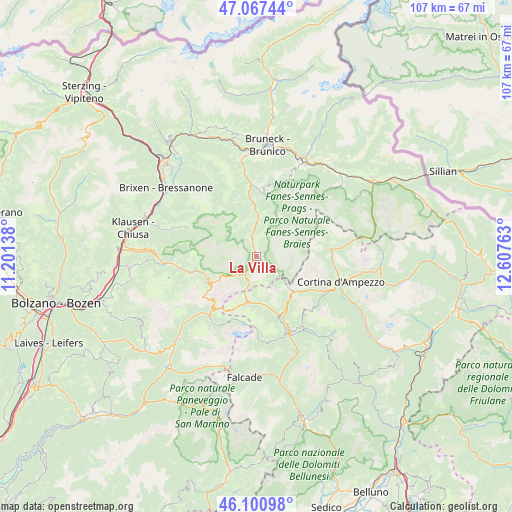
La Villa GPS coordinates[2]
46° 35' 10.896" North, 11° 54' 16.2" East
| Map corner | latitude | longitude |
|---|---|---|
| Upper-left | 47.06744°, | 11.20138° |
| Center: | 46.58636°, | 11.9045° |
| Lower-right: | 46.10098°, | 12.60763° |
| Map W x H: | 107.5×107.5 km | = 66.8×66.8mi |
| max Lat: | 47.04031° ⇑1.2% North |
| La Villa: | 46.58636° |
| min Lat: | ⇓98.8% South 35.50142° |
| min Long | La Villa | max Long |
| 6.69888° | 11.9045° | 18.48682° |
| W 54.6%⇐ | ⇒45.4% E |
Elevation
Elevation of La Villa is 1416 m = 4646 ft, and this is 1109.3 m = 3639 ft above average elevation for this country.
| Max E: |
2085 m = 6841 ft | 0.5% |
| La Villa | 1416 m 4646 ft | |
| Avg. | 306.7 m = 1006 ft | |
Min E: |
-4 m = -13 ft | 99.5% |
See also: Italy elevation on elevation.city.
Geographical zone
La Villa is located in North temperate zone (between Tropic of Cancer and the Arctic Circle). Distance of this North polar circle is 2221.3 km =1380.3 mi to North.| Distance of | km | miles | from La Villa |
|---|---|---|---|
| North Pole | 4827.1 | 2999.4 | to North |
| Arctic Circle | 2221.3 | 1380.3 | to North |
| Tropic Cancer | 2574 | 1599.4 | to South |
| Equator | 5179.9 | 3218.6 | to South |


Nearby cities:
15 places around La Villa: (largest is in red/bold)
• Alba-Penia
16.5 km =10.3 mi,  209°
209°
• Badia
2.5 km =1.6 mi,  345°
345°
• Campitello di Fassa
17.5 km =10.9 mi,  225°
225°
• Canazei
16 km =9.9 mi,  220°
220°
• Colle Santa Lucia
17.5 km =10.9 mi,  151°
151°
• Corvara in Badia
4.7 km =2.9 mi, 210°
• La Valle - Wengen
8.1 km =5 mi,  10°
10°
• Livinallongo del Col di Lana
12.2 km =7.6 mi,  161°
161°
• Ortisei
17.8 km =11.1 mi,  266°
266°
• Rocca Pietore
17.8 km =11.1 mi, 161°
• San Genesio
8.1 km =5 mi, 10°
• San Martino in Badia
10.6 km =6.6 mi,  357°
357°
• San Vigilio
12.7 km =7.9 mi, 9°
• Santa Cristina Valgardena
13.4 km =8.3 mi,  258°
258°
• Selva
11.6 km =7.2 mi,  252°
252°
Sources, notices
• [Note1] Compared only with cities in Italy existing in our database
• [Src1] Map data: © OpenStreetMap contributors (CC-BY-SA)
• [Src2] Other city data from geonames.org with taken over terms of usage.
• [Src3] Geographical zone / Annual Mean Temperature by Robert A. Rohde @ Wikipedia
